Weather Alert in Wisconsin
Special Weather Statement issued February 18 at 4:38AM CST by NWS Green Bay WI
AREAS AFFECTED: Shawano; Waupaca; Outagamie; Brown; Winnebago; Calumet; Manitowoc; Southern Oconto County
DESCRIPTION: At 437 AM CST, trained weather spotters reported strong thunderstorms along a line extending from 12 miles west of Clintonville to near Campbellsport. Movement was northeast at 50 mph. HAZARD...Half inch hail. SOURCE...Trained weather spotters. IMPACT...Minor hail damage to vegetation is possible. Strong thunderstorms will be near... Oshkosh, New London, Northern Lake Winnebago, and Central Lake Winnebago around 440 AM CST. Menasha and Clintonville around 445 AM CST. Appleton and Embarrass around 450 AM CST. Little Chute, Kimberly, Chilton, Black Creek, High Cliff State Park, Darboy, and St Anna around 455 AM CST. Shawano, Kaukauna, and Navarino Wildlife Area around 500 AM CST. Brillion and Camp Rokilio Scout Camp around 505 AM CST. Valders and St. Nazianz around 510 AM CST. Green Bay, Pulaski, and Cleveland around 515 AM CST. Other locations impacted by these storms include Butte Des Morts, Northport, Wayside, Rose Lawn, Freedom, Newtonberg, Howard, Allenville, St John, and Shirley.
INSTRUCTION: If outdoors, consider seeking shelter inside a building. Frequent cloud to ground lightning is occurring with these storms. Lightning can strike 10 miles away from a thunderstorm. Seek a safe shelter inside a building or vehicle.
Want more detail? Get the Complete 7 Day and Night Detailed Forecast!
Current U.S. National Radar--Current
The Current National Weather Radar is shown below with a UTC Time (subtract 5 hours from UTC to get Eastern Time).

National Weather Forecast--Current
The Current National Weather Forecast and National Weather Map are shown below.

National Weather Forecast for Tomorrow
Tomorrow National Weather Forecast and Tomorrow National Weather Map are show below.

North America Water Vapor (Moisture)
This map shows recent moisture content over North America. Bright and colored areas show high moisture (ie, clouds); brown indicates very little moisture present; black indicates no moisture.

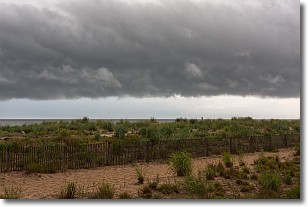
Weather Topic: What are Shelf Clouds?
Home - Education - Cloud Types - Shelf Clouds
 Next Topic: Sleet
A shelf cloud is similar to a wall cloud, but forms at the front
of a storm cloud, instead of at the rear, where wall clouds form.
A shelf cloud is caused by a series of events set into motion by the advancing
storm; first, cool air settles along the ground where precipitation has just fallen.
As the cool air is brought in, the warmer air is displaced, and rises above it,
because it is less dense. When the warmer air reaches the bottom of the storm cloud,
it begins to cool again, and the resulting condensation is a visible shelf cloud.
Next Topic: Sleet
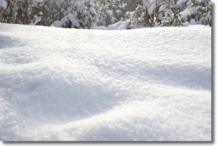
Weather Topic: What is Snow?
Home - Education - Precipitation - Snow
 Next Topic: Stratocumulus Clouds
Snow is precipitation taking the form of ice crystals. Each ice crystal, or snowflake,
has unique characteristics, but all of them grow in a hexagonal structure.
Snowfall can last for sustained periods of time and result in significant buildup
of snow on the ground.
On the earth's surface, snow starts out light and powdery, but as it begins to melt
it tends to become more granular, producing small bits of ice which have the consistency of
sand. After several cycles of melting and freezing, snow can become very dense
and ice-like, commonly known as snow pack.
Next Topic: Stratocumulus Clouds
Current conditions powered by WeatherAPI.com


