Weather Alert in North Carolina
Severe Thunderstorm Warning issued September 6 at 3:34PM EDT until September 6 at 4:00PM EDT by NWS Blacksburg VA
AREAS AFFECTED: Caswell, NC
DESCRIPTION: At 334 PM EDT, a severe thunderstorm was located over Leasburg, or 7 miles east of Yanceyville, moving northeast at 20 mph. HAZARD...60 mph wind gusts and quarter size hail. SOURCE...Radar indicated. IMPACT...Hail damage to vehicles is expected. Expect wind damage to roofs, siding, and trees. Locations impacted include... Yanceyville... Prospect Hill... Jericho... Leasburg... Topnot... Hightowers... and Baynes.
INSTRUCTION: Prepare immediately for LARGE HAIL AND DAMAGING WINDS. For your safety, move to an interior room on the lowest floor of a sturdy building. Stay away from windows. Locally heavy rain will quickly reduce visibility and result in ponding of water on roadways, standing water in low lying areas, and minor flooding of creeks, streams, and areas of poor drainage. Drivers are urged to slow down and use extra caution to avoid hydroplaning. When it is safe to do so, please send your reports of hail of any size, as well as reports of any wind damage, including downed trees or large limbs, to the National Weather Service by calling toll free at 1...8 6 6...2 1 5...4 3 2 4. Reports and pictures can also be shared on the National Weather Service Blacksburg Facebook page and on X.
Want more detail? Get the Complete 7 Day and Night Detailed Forecast!
Current U.S. National Radar--Current
The Current National Weather Radar is shown below with a UTC Time (subtract 5 hours from UTC to get Eastern Time).

National Weather Forecast--Current
The Current National Weather Forecast and National Weather Map are shown below.

National Weather Forecast for Tomorrow
Tomorrow National Weather Forecast and Tomorrow National Weather Map are show below.

North America Water Vapor (Moisture)
This map shows recent moisture content over North America. Bright and colored areas show high moisture (ie, clouds); brown indicates very little moisture present; black indicates no moisture.

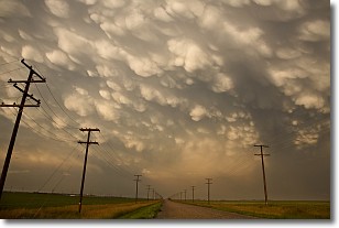
Weather Topic: What are Mammatus Clouds?
Home - Education - Cloud Types - Mammatus Clouds
 Next Topic: Nimbostratus Clouds
A mammatus cloud is a cloud with a unique feature which resembles
a web of pouches hanging along the base of the cloud.
In the United States, mammatus clouds tend to form in the warmer months, commonly
in the Midwest and eastern regions.
While they usually form at the bottom of a cumulonimbis cloud, they can also form
under altostratus, altocumulus, stratocumulus, and cirrus clouds. Mammatus clouds
warn that severe weather is close.
Next Topic: Nimbostratus Clouds
Weather Topic: What is Precipitation?
Home - Education - Precipitation - Precipitation
 Next Topic: Rain
Precipitation can refer to many different forms of water that
may fall from clouds. Precipitation occurs after a cloud has become saturated to
the point where its water particles are more dense than the air below the cloud.
In most cases, precipitation will reach the ground, but it is not uncommon for
precipitation to evaporate before it reaches the earth's surface.
When precipitation evaporates before it contacts the ground it is called Virga.
Graupel, hail, sleet, rain, drizzle, and snow are forms of precipitation, but fog
and mist are not considered precipitation because the water vapor which
constitutes them isn't dense enough to fall to the ground.
Next Topic: Rain
Current conditions powered by WeatherAPI.com


