Weather Alert in Kansas
Flood Watch issued August 27 at 2:30PM CDT until August 28 at 1:00PM CDT by NWS Wichita KS
AREAS AFFECTED: Ellsworth; Saline; Rice; McPherson; Marion; Chase; Reno; Harvey; Butler; Greenwood; Woodson; Allen; Sedgwick; Elk; Wilson; Neosho; Montgomery; Labette
DESCRIPTION: * WHAT...Flooding caused by excessive rainfall continues to be possible. * WHERE...Portions of Central, South Central, and Southeast Kansas, including the following counties, in Central Kansas, Chase, Ellsworth, Marion, McPherson, Rice and Saline. In South Central Kansas, Butler, Harvey, Reno and Sedgwick. In Southeast Kansas, Allen, Elk, Greenwood, Labette, Montgomery, Neosho, Wilson and Woodson. * WHEN...From 7 PM CDT this evening through Thursday afternoon. * IMPACTS...Excessive runoff may result in flooding of rivers, creeks, streams, and other low-lying and flood-prone locations. Low-water crossings may be flooded. * ADDITIONAL DETAILS... - A narrow zone of very heavy rainfall is expected to develop overnight into early Thursday morning along a Salina-to- Chanute line. Rainfall totals around 2 to 5 inches are currently being forecast with locally higher amounts possible. Though it has been relatively dry over the past 2 to 3 weeks, this amount of rainfall in a short amount of time could cause areas of localized flooding across the watch area.
INSTRUCTION: You should monitor later forecasts and be alert for possible Flood Warnings. Those living in areas prone to flooding should be prepared to take action should flooding develop. Be especially cautious at night when it is harder to recognize the dangers of flooding.
Want more detail? Get the Complete 7 Day and Night Detailed Forecast!
Current U.S. National Radar--Current
The Current National Weather Radar is shown below with a UTC Time (subtract 5 hours from UTC to get Eastern Time).

National Weather Forecast--Current
The Current National Weather Forecast and National Weather Map are shown below.

National Weather Forecast for Tomorrow
Tomorrow National Weather Forecast and Tomorrow National Weather Map are show below.

North America Water Vapor (Moisture)
This map shows recent moisture content over North America. Bright and colored areas show high moisture (ie, clouds); brown indicates very little moisture present; black indicates no moisture.

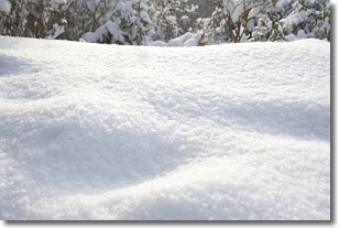
Weather Topic: What is Snow?
Home - Education - Precipitation - Snow
 Next Topic: Stratocumulus Clouds
Snow is precipitation taking the form of ice crystals. Each ice crystal, or snowflake,
has unique characteristics, but all of them grow in a hexagonal structure.
Snowfall can last for sustained periods of time and result in significant buildup
of snow on the ground.
On the earth's surface, snow starts out light and powdery, but as it begins to melt
it tends to become more granular, producing small bits of ice which have the consistency of
sand. After several cycles of melting and freezing, snow can become very dense
and ice-like, commonly known as snow pack.
Next Topic: Stratocumulus Clouds
Weather Topic: What are Stratus Clouds?
Home - Education - Cloud Types - Stratus Clouds
 Next Topic: Wall Clouds
Stratus clouds are similar to altostratus clouds, but form at a
lower altitude and are identified by their fog-like appearance, lacking the
distinguishing features of most clouds.
Stratus clouds are wider than most clouds, and their base has a smooth, uniform
look which is lighter in color than a nimbostratus cloud.
The presence of a stratus cloud indicates the possibility of minor precipitation,
such as drizzle, but heavier precipitation does not typically arrive in the form
of a stratus cloud.
Next Topic: Wall Clouds
Current conditions powered by WeatherAPI.com


