Weather Alert in Idaho
Heat Advisory issued June 8 at 11:57AM PDT until June 10 at 9:00PM PDT by NWS Spokane WA
AREAS AFFECTED: Lewiston Area; Lower Garfield and Asotin Counties; Washington Palouse; Upper Columbia Basin
DESCRIPTION: * WHAT...High temperatures between 91 and 101 degrees. * WHERE...Ritzville, Lapwai, Harrington, La Crosse, Lewiston Grade, Gifford, Culdesac, Pullman, Creston, Uniontown, Odessa, Colfax, Oakesdale, Clarkston, Coulee City, Rosalia, Tekoa, Peck, Alpowa Summit, Pomeroy, Wilbur, Grand Coulee, and Lewiston. * WHEN...From noon Monday to 9 PM PDT Tuesday. * IMPACTS...Increased risk of heat-related illnesses. * ADDITIONAL DETAILS...Low temperatures in the 60s will provide little relief at night. Be mindful that lakes, rivers, and streams are still cold.
INSTRUCTION: Drink plenty of fluids, stay in an air-conditioned room, stay out of the sun, and check up on relatives and neighbors.
Want more detail? Get the Complete 7 Day and Night Detailed Forecast!
Current U.S. National Radar--Current
The Current National Weather Radar is shown below with a UTC Time (subtract 5 hours from UTC to get Eastern Time).

National Weather Forecast--Current
The Current National Weather Forecast and National Weather Map are shown below.

National Weather Forecast for Tomorrow
Tomorrow National Weather Forecast and Tomorrow National Weather Map are show below.

North America Water Vapor (Moisture)
This map shows recent moisture content over North America. Bright and colored areas show high moisture (ie, clouds); brown indicates very little moisture present; black indicates no moisture.

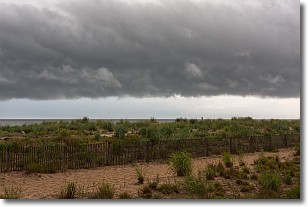
Weather Topic: What are Shelf Clouds?
Home - Education - Cloud Types - Shelf Clouds
 Next Topic: Sleet
A shelf cloud is similar to a wall cloud, but forms at the front
of a storm cloud, instead of at the rear, where wall clouds form.
A shelf cloud is caused by a series of events set into motion by the advancing
storm; first, cool air settles along the ground where precipitation has just fallen.
As the cool air is brought in, the warmer air is displaced, and rises above it,
because it is less dense. When the warmer air reaches the bottom of the storm cloud,
it begins to cool again, and the resulting condensation is a visible shelf cloud.
Next Topic: Sleet
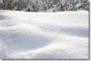
Weather Topic: What is Snow?
Home - Education - Precipitation - Snow
 Next Topic: Stratocumulus Clouds
Snow is precipitation taking the form of ice crystals. Each ice crystal, or snowflake,
has unique characteristics, but all of them grow in a hexagonal structure.
Snowfall can last for sustained periods of time and result in significant buildup
of snow on the ground.
On the earth's surface, snow starts out light and powdery, but as it begins to melt
it tends to become more granular, producing small bits of ice which have the consistency of
sand. After several cycles of melting and freezing, snow can become very dense
and ice-like, commonly known as snow pack.
Next Topic: Stratocumulus Clouds
Current conditions powered by WeatherAPI.com


