Weather Alert in California
Flood Advisory issued February 17 at 8:49PM PST until February 18 at 6:00AM PST by NWS Los Angeles/Oxnard CA
AREAS AFFECTED: Los Angeles, CA; Ventura, CA
DESCRIPTION: * WHAT...Flooding caused by excessive rainfall is expected. * WHERE...A portion of southwest California, including much of the following counties, Los Angeles and Ventura. * WHEN...Until 600 AM PST Wednesday. * IMPACTS...Minor flooding in low-lying and poor drainage areas. Rock and mud slides possible. Minor debris flows possible. * ADDITIONAL DETAILS... - At 848 PM PST, Doppler radar indicated heavy showers and isolated thunderstorms developing across the region. Activity will continue through the pre-dawn hours of Wednesday. Minor flooding is ongoing or expected to begin shortly in the advisory area, and continue through the overnight hours. Rock and mud slides possible. Minor debris flows possible. - Some locations that will experience flooding include... Long Beach, Oxnard, Thousand Oaks, Simi Valley, Ventura, Camarillo, Fillmore, Malibu, Ojai, Chatsworth, Woodland Hills, Northridge, Encino, Van Nuys, Agoura Hills, Santa Clarita, North Hollywood, Santa Monica and Beverly Hills. And burn scars across the Flood Advisory area. - http://www.weather.gov/safety/flood
INSTRUCTION: Turn around, don't drown when encountering flooded roads. Most flood deaths occur in vehicles. Be aware of the potential for rock slides and mud slides in areas of steep terrain.
Want more detail? Get the Complete 7 Day and Night Detailed Forecast!
Current U.S. National Radar--Current
The Current National Weather Radar is shown below with a UTC Time (subtract 5 hours from UTC to get Eastern Time).

National Weather Forecast--Current
The Current National Weather Forecast and National Weather Map are shown below.

National Weather Forecast for Tomorrow
Tomorrow National Weather Forecast and Tomorrow National Weather Map are show below.

North America Water Vapor (Moisture)
This map shows recent moisture content over North America. Bright and colored areas show high moisture (ie, clouds); brown indicates very little moisture present; black indicates no moisture.

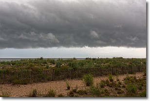
Weather Topic: What are Shelf Clouds?
Home - Education - Cloud Types - Shelf Clouds
 Next Topic: Sleet
A shelf cloud is similar to a wall cloud, but forms at the front
of a storm cloud, instead of at the rear, where wall clouds form.
A shelf cloud is caused by a series of events set into motion by the advancing
storm; first, cool air settles along the ground where precipitation has just fallen.
As the cool air is brought in, the warmer air is displaced, and rises above it,
because it is less dense. When the warmer air reaches the bottom of the storm cloud,
it begins to cool again, and the resulting condensation is a visible shelf cloud.
Next Topic: Sleet
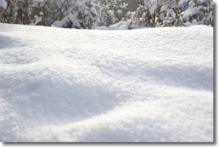
Weather Topic: What is Snow?
Home - Education - Precipitation - Snow
 Next Topic: Stratocumulus Clouds
Snow is precipitation taking the form of ice crystals. Each ice crystal, or snowflake,
has unique characteristics, but all of them grow in a hexagonal structure.
Snowfall can last for sustained periods of time and result in significant buildup
of snow on the ground.
On the earth's surface, snow starts out light and powdery, but as it begins to melt
it tends to become more granular, producing small bits of ice which have the consistency of
sand. After several cycles of melting and freezing, snow can become very dense
and ice-like, commonly known as snow pack.
Next Topic: Stratocumulus Clouds
Current conditions powered by WeatherAPI.com


