Weather Alert in Texas
Severe Thunderstorm Warning issued June 8 at 11:38PM CDT until June 9 at 12:15AM CDT by NWS Shreveport LA
AREAS AFFECTED: Camp, TX; Cass, TX; Franklin, TX; Gregg, TX; Harrison, TX; Marion, TX; Morris, TX; Rusk, TX; Smith, TX; Titus, TX; Upshur, TX; Wood, TX
DESCRIPTION: At 1135 PM CDT, severe thunderstorms were located along a line extending from near Mount Pleasant to 6 miles south of Scroggins to near Grand Saline to near Kaufman, moving east at 50 mph. THESE ARE DESTRUCTIVE STORMS including the cities of and areas around Gilmer, TX and Pittsburg, TX. HAZARD...80 mph wind gusts and half dollar size hail. SOURCE...Radar indicated. IMPACT...Flying debris will be dangerous to those caught without shelter. Mobile homes will be heavily damaged. Expect considerable damage to roofs, windows, and vehicles. Extensive tree damage and power outages are likely. Locations impacted include... Tyler, Longview, Mount Pleasant, Kilgore, Whitehouse, White Oak, Gladewater, Gilmer, Mineola, Pittsburg, Winnsboro, Leesburg, Lindale, Mount Vernon, Daingerfield, Overton, Bullard, Troup, Quitman, and Lone Star.
INSTRUCTION: Remain alert for a possible tornado! Tornadoes can develop quickly from severe thunderstorms. If you spot a tornado go at once into the basement or small central room in a sturdy structure. For your protection move to an interior room on the lowest floor of a building. These storms are producing destructive winds and large damaging hail. SEEK SHELTER NOW inside a sturdy structure and stay away from windows. Continuous cloud to ground lightning is occurring with these storms. Move indoors immediately. Lightning is one of nature's leading killers. Remember, if you can hear thunder, you are close enough to be struck by lightning. Torrential rainfall is occurring with these storms, and may lead to flash flooding. Do not drive your vehicle through flooded roadways.
Want more detail? Get the Complete 7 Day and Night Detailed Forecast!
Current U.S. National Radar--Current
The Current National Weather Radar is shown below with a UTC Time (subtract 5 hours from UTC to get Eastern Time).

National Weather Forecast--Current
The Current National Weather Forecast and National Weather Map are shown below.

National Weather Forecast for Tomorrow
Tomorrow National Weather Forecast and Tomorrow National Weather Map are show below.

North America Water Vapor (Moisture)
This map shows recent moisture content over North America. Bright and colored areas show high moisture (ie, clouds); brown indicates very little moisture present; black indicates no moisture.

Weather Topic: What is Precipitation?
Home - Education - Precipitation - Precipitation
 Next Topic: Rain
Precipitation can refer to many different forms of water that
may fall from clouds. Precipitation occurs after a cloud has become saturated to
the point where its water particles are more dense than the air below the cloud.
In most cases, precipitation will reach the ground, but it is not uncommon for
precipitation to evaporate before it reaches the earth's surface.
When precipitation evaporates before it contacts the ground it is called Virga.
Graupel, hail, sleet, rain, drizzle, and snow are forms of precipitation, but fog
and mist are not considered precipitation because the water vapor which
constitutes them isn't dense enough to fall to the ground.
Next Topic: Rain
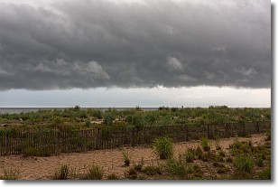
Weather Topic: What are Shelf Clouds?
Home - Education - Cloud Types - Shelf Clouds
 Next Topic: Sleet
A shelf cloud is similar to a wall cloud, but forms at the front
of a storm cloud, instead of at the rear, where wall clouds form.
A shelf cloud is caused by a series of events set into motion by the advancing
storm; first, cool air settles along the ground where precipitation has just fallen.
As the cool air is brought in, the warmer air is displaced, and rises above it,
because it is less dense. When the warmer air reaches the bottom of the storm cloud,
it begins to cool again, and the resulting condensation is a visible shelf cloud.
Next Topic: Sleet
Current conditions powered by WeatherAPI.com


