Weather Alert in California
Red Flag Warning issued September 1 at 12:04PM PDT until September 2 at 8:00PM PDT by NWS Eureka CA
AREAS AFFECTED: Lower Middle Klamath; Trinity
DESCRIPTION: ...ISOLATED DRY THUNDERSTORMS TUESDAY AFTERNOON AND EARLY EVENING... .Isolated dry thunderstorms are possible over the interior Tuesday afternoon and into early evening. Threats include erratic gusty winds and lightning. Lightning on dry fuels may lead to new fire starts. In addition, gusty winds combined with hot temperatures and low relative humidity will also produce near critical fire weather conditions. Existing fires and any new fireS will have the potential to spread rapidly. The National Weather Service in Eureka has issued a Red Flag Warning, which is in effect from 1 PM to 8 PM PDT Tuesday. The Fire Weather Watch is no longer in effect. * THUNDERSTORMS...Isolated dry storms over high terrain in the afternoon and early evening hours. * OUTFLOW WINDS...Gusty and erratic outflow winds over 40 mph possible. * IMPACTS...Any fires that develop will likely spread rapidly. Outdoor burning is not recommended. * Additional Impacts...Hot, dry weather and breezy winds will increase the fire danger even in areas away from thunderstorms.
INSTRUCTION: A Red Flag Warning means that critical fire weather conditions are either occurring now, or will shortly. A combination of strong winds, low relative humidity, and warm temperatures can contribute to extreme fire behavior.
Want more detail? Get the Complete 7 Day and Night Detailed Forecast!
Current U.S. National Radar--Current
The Current National Weather Radar is shown below with a UTC Time (subtract 5 hours from UTC to get Eastern Time).

National Weather Forecast--Current
The Current National Weather Forecast and National Weather Map are shown below.

National Weather Forecast for Tomorrow
Tomorrow National Weather Forecast and Tomorrow National Weather Map are show below.

North America Water Vapor (Moisture)
This map shows recent moisture content over North America. Bright and colored areas show high moisture (ie, clouds); brown indicates very little moisture present; black indicates no moisture.

Weather Topic: What is Condensation?
Home - Education - Precipitation - Condensation
 Next Topic: Contrails
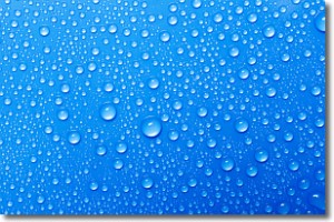
Condensation is the process which creates clouds, and therefore
it is a crucial process in the water cycle.
Condensation is the change of matter from a state of gas into a state of liquid,
and it happens because water molecules release heat into the atmosphere and
become organized into a more closely packed structure, what we might see as
water droplets.
Water is always present in the air around us as a vapor, but it's too small for
us to see. When water undergoes the process of condensation it becomes organized
into visible water droplets. You've probably seen condensation happen before on the
surface of a cold drink!
Next Topic: Contrails
Weather Topic: What are Cumulonimbus Clouds?
Home - Education - Cloud Types - Cumulonimbus Clouds
 Next Topic: Cumulus Clouds
The final form taken by a growing cumulus cloud is the
cumulonimbus cloud, which is very tall and dense.
The tower of a cumulonimbus cloud can soar 23 km into the atmosphere, although
most commonly they stop growing at an altitude of 6 km.
Even small cumulonimbus clouds appear very large in comparison to other cloud types.
They can signal the approach of stormy weather, such as thunderstorms or blizzards.
Next Topic: Cumulus Clouds
Current conditions powered by WeatherAPI.com


