Weather Alert in Texas
Special Weather Statement issued April 24 at 5:58AM CDT by NWS Fort Worth TX
AREAS AFFECTED: Comanche; Mills; Hamilton
DESCRIPTION: At 557 AM CDT, Doppler radar was tracking a strong thunderstorm 7 miles east of Goldthwaite, or 24 miles northeast of San Saba, moving northeast at 30 mph. HAZARD...Winds in excess of 40 mph and half inch hail. SOURCE...Radar indicated. IMPACT...Gusty winds could knock down tree limbs and blow around unsecured objects. Minor damage to outdoor objects is possible. This storm will remain over mainly rural areas of southwestern Hamilton, northeastern Mills and south central Comanche Counties, including the following locations... Shive, Center City, Energy, Star, Pottsville, Bozar, Pecan Wells, Indian Gap, and Caradan.
INSTRUCTION: If outdoors, consider seeking shelter inside a building.
Want more detail? Get the Complete 7 Day and Night Detailed Forecast!
Current U.S. National Radar--Current
The Current National Weather Radar is shown below with a UTC Time (subtract 5 hours from UTC to get Eastern Time).

National Weather Forecast--Current
The Current National Weather Forecast and National Weather Map are shown below.

National Weather Forecast for Tomorrow
Tomorrow National Weather Forecast and Tomorrow National Weather Map are show below.

North America Water Vapor (Moisture)
This map shows recent moisture content over North America. Bright and colored areas show high moisture (ie, clouds); brown indicates very little moisture present; black indicates no moisture.

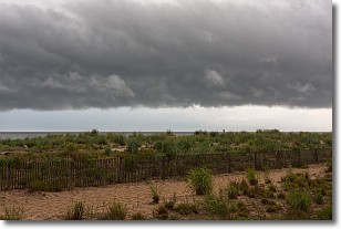
Weather Topic: What are Shelf Clouds?
Home - Education - Cloud Types - Shelf Clouds
 Next Topic: Sleet
A shelf cloud is similar to a wall cloud, but forms at the front
of a storm cloud, instead of at the rear, where wall clouds form.
A shelf cloud is caused by a series of events set into motion by the advancing
storm; first, cool air settles along the ground where precipitation has just fallen.
As the cool air is brought in, the warmer air is displaced, and rises above it,
because it is less dense. When the warmer air reaches the bottom of the storm cloud,
it begins to cool again, and the resulting condensation is a visible shelf cloud.
Next Topic: Sleet
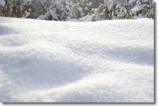
Weather Topic: What is Snow?
Home - Education - Precipitation - Snow
 Next Topic: Stratocumulus Clouds
Snow is precipitation taking the form of ice crystals. Each ice crystal, or snowflake,
has unique characteristics, but all of them grow in a hexagonal structure.
Snowfall can last for sustained periods of time and result in significant buildup
of snow on the ground.
On the earth's surface, snow starts out light and powdery, but as it begins to melt
it tends to become more granular, producing small bits of ice which have the consistency of
sand. After several cycles of melting and freezing, snow can become very dense
and ice-like, commonly known as snow pack.
Next Topic: Stratocumulus Clouds
Current conditions powered by WeatherAPI.com


