Weather Alert in California
Flood Warning issued February 26 at 8:33AM PST until February 26 at 10:18PM PST by NWS Sacramento CA
AREAS AFFECTED: Butte, CA; Glenn, CA
DESCRIPTION: ...The Flood Warning is extended for the following rivers in California... Sacramento River At Ord Ferry affecting Butte and Glenn Counties. ...The Flood Warning is cancelled for the following rivers in California... Sacramento River At Vina Woodson Bridge affecting Tehama County. Sacramento River At Tehama Bridge affecting Tehama County. .Minor flooding is occurring at Ord Ferry due to recent precipitation. For the Upper Sacramento River...including Ord Ferry...Minor flooding is forecast. Water levels at Tehama Bridge and Vina Woodson Bridge have decreased as the flow works its way through the river system. * WHAT...Minor flooding is forecast. * WHERE...Sacramento River at Ord Ferry. * WHEN...Until late this evening. * IMPACTS...At 110.3 feet, Head cuts in 3Bs silt weir start overflow into Butte Basin, flooding dips on Ord Ferry Road west of River Road in Butte County. Persistent flows at or above this level increase flooding in Butte Basin. Ord Ferry Road and additional roads in Glenn and Colusa counties are closed due to flooding. At 112.0 feet, At 112 to 113 feet, water inundates portions of Ord Ferry Road (County Road 32) in Glenn County from CA-45 east to the county line at the Sacramento River. At 113.8 feet, Design overflow level for M&T, 3Bs and Goose Lake flood control facilities to divert flood flows into Butte Basin. M&T overflows close River Road from Ord Ferry Road to Chico Road. Ord Ferry Road is already closed. At 114.0 feet, Designated flood stage left bank. * ADDITIONAL DETAILS... - At 7:45 AM PST Thursday the stage was 113.1 feet. - Bankfull stage is 114.0 feet. - Forecast...The river is expected to rise above flood stage this morning to a crest of 114.3 feet this afternoon. It will then fall below flood stage late this afternoon. - Flood stage is 114.0 feet. - Flood History...This crest compares to a previous crest of 114.3 feet on 01/15/2023. - http://www.weather.gov/safety/flood
INSTRUCTION: Turn around, don't drown when encountering flooded roads. Most flood deaths occur in vehicles. For more hydrologic information and stage definitions refer to the following web site: wrh.noaa.gov/sto/hydro_data.php The next statement will be issued this morning at 945 AM PST.
Want more detail? Get the Complete 7 Day and Night Detailed Forecast!
Current U.S. National Radar--Current
The Current National Weather Radar is shown below with a UTC Time (subtract 5 hours from UTC to get Eastern Time).

National Weather Forecast--Current
The Current National Weather Forecast and National Weather Map are shown below.

National Weather Forecast for Tomorrow
Tomorrow National Weather Forecast and Tomorrow National Weather Map are show below.

North America Water Vapor (Moisture)
This map shows recent moisture content over North America. Bright and colored areas show high moisture (ie, clouds); brown indicates very little moisture present; black indicates no moisture.

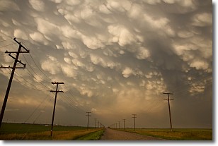
Weather Topic: What are Mammatus Clouds?
Home - Education - Cloud Types - Mammatus Clouds
 Next Topic: Nimbostratus Clouds
A mammatus cloud is a cloud with a unique feature which resembles
a web of pouches hanging along the base of the cloud.
In the United States, mammatus clouds tend to form in the warmer months, commonly
in the Midwest and eastern regions.
While they usually form at the bottom of a cumulonimbis cloud, they can also form
under altostratus, altocumulus, stratocumulus, and cirrus clouds. Mammatus clouds
warn that severe weather is close.
Next Topic: Nimbostratus Clouds
Weather Topic: What is Precipitation?
Home - Education - Precipitation - Precipitation
 Next Topic: Rain
Precipitation can refer to many different forms of water that
may fall from clouds. Precipitation occurs after a cloud has become saturated to
the point where its water particles are more dense than the air below the cloud.
In most cases, precipitation will reach the ground, but it is not uncommon for
precipitation to evaporate before it reaches the earth's surface.
When precipitation evaporates before it contacts the ground it is called Virga.
Graupel, hail, sleet, rain, drizzle, and snow are forms of precipitation, but fog
and mist are not considered precipitation because the water vapor which
constitutes them isn't dense enough to fall to the ground.
Next Topic: Rain
Current conditions powered by WeatherAPI.com


