Weather Alert in Oregon
Extreme Heat Warning issued August 22 at 2:08PM PDT until August 26 at 11:00PM PDT by NWS Portland OR
AREAS AFFECTED: Lower Columbia River; Tualatin Valley; West Hills and Chehalem Mountains; Inner Portland Metro; East Portland Metro; Outer Southeast Portland Metro; West Central Willamette Valley; East Central Willamette Valley; Benton County Lowlands; Linn County Lowlands; Lane County Lowlands; West Columbia River Gorge of Oregon above 500 ft; West Columbia River Gorge I-84 Corridor; Upper Hood River Valley; Central Columbia River Gorge I-84 Corridor; Clackamas County Cascade Foothills; Cascade Foothills of Marion and Linn Counties; Lane County Cascade Foothills; Cowlitz County Lowlands; North Clark County Lowlands; Inner Vancouver Metro; East Clark County Lowlands; South Washington Cascade Foothills; West Columbia River Gorge - SR 14; Central Columbia River Gorge - SR 14
DESCRIPTION: * WHAT...Dangerously hot conditions with high temperatures of 97-103F and overnight low temperatures of 60-70F expected, except low to mid 70s in the Columbia River Gorge. * WHERE...Greater Portland/Vancouver Metro, Western and Central Columbia River Gorge, the Corbett area and the Hood River Valley, Central and Southern Willamette Valley, Foothills of the Northern and Central Oregon Cascades, Lower Columbia River and Cowlitz River Valleys, and South Washington Cascade Foothills. * WHEN...Until 11 PM PDT Tuesday. * IMPACTS...Heat related illnesses increase significantly during extreme heat events, especially for those spending time outdoors or without access to adequate cooling. * ADDITIONAL DETAILS...Friday, Saturday, and Sunday will be the hottest days. The warmest overnight lows are expected to occur in the Columbia River Gorge and in urban areas from Salem northward.
INSTRUCTION: Drink plenty of fluids, stay in a cool place during the heat of the day, stay out of the sunshine, and check up on relatives and neighbors. For those without air conditioning, use fans to keep air moving. Keeps windows closed during the day and open at night, unless air quality is degraded due to wildfire smoke. Do not leave young children and pets in unattended vehicles. Car interiors will reach lethal temperatures in a matter of minutes. Take extra precautions when outside. Wear lightweight and loose fitting clothing. Try to limit strenuous activities to early morning or evening. Take action when you see symptoms of heat exhaustion and heat stroke.
Want more detail? Get the Complete 7 Day and Night Detailed Forecast!
Current U.S. National Radar--Current
The Current National Weather Radar is shown below with a UTC Time (subtract 5 hours from UTC to get Eastern Time).

National Weather Forecast--Current
The Current National Weather Forecast and National Weather Map are shown below.

National Weather Forecast for Tomorrow
Tomorrow National Weather Forecast and Tomorrow National Weather Map are show below.

North America Water Vapor (Moisture)
This map shows recent moisture content over North America. Bright and colored areas show high moisture (ie, clouds); brown indicates very little moisture present; black indicates no moisture.

Weather Topic: What is Hail?
Home - Education - Precipitation - Hail
 Next Topic: Hole Punch Clouds
Hail is a form of precipitation which is recognized by large solid balls or
clumps of ice. Hail is created by thunderstorm clouds with strong updrafts of wind.
As the hailstones remain in the updraft, ice is deposited onto them until their
weight becomes heavy enough for them to fall to the earth's surface.
Hail storms can cause significant damage to crops, aircrafts, and man-made structures,
despite the fact that the duration is usually less than ten minutes.
Next Topic: Hole Punch Clouds
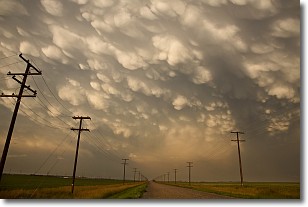
Weather Topic: What are Mammatus Clouds?
Home - Education - Cloud Types - Mammatus Clouds
 Next Topic: Nimbostratus Clouds
A mammatus cloud is a cloud with a unique feature which resembles
a web of pouches hanging along the base of the cloud.
In the United States, mammatus clouds tend to form in the warmer months, commonly
in the Midwest and eastern regions.
While they usually form at the bottom of a cumulonimbis cloud, they can also form
under altostratus, altocumulus, stratocumulus, and cirrus clouds. Mammatus clouds
warn that severe weather is close.
Next Topic: Nimbostratus Clouds
Current conditions powered by WeatherAPI.com


