Weather Alert in New York
Flood Advisory issued February 22 at 5:37PM EST until February 23 at 4:00AM EST by NWS Upton NY
AREAS AFFECTED: Orange, NY; Putnam, NY; Rockland, NY; Westchester, NY
DESCRIPTION: * WHAT...Around 1 ft of inundation above ground level likely in vulnerable areas near the waterfront and shoreline. * WHERE...A portion of southeast New York, including the following counties, Orange, Putnam, Rockland and Westchester. * WHEN...Until 400 AM EST Monday. * IMPACTS...Minor coastal flooding is expected in the most vulnerable locations near the waterfront and shoreline. Expect around 1 ft of inundation above ground level in low lying, vulnerable areas. Some roads and low lying property including parking lots, parks, and lawns near the waterfront will experience shallow flooding. * ADDITIONAL DETAILS... - At 529 PM EST, This water level forecast has been leaned towards a high end scenario, providing a margin of safety. It is highly dependent on timing of windshift from northeast to north storm force winds with respect to the time of high tide. If shift to northerly winds occurs earlier than time of high tide, water levels will fall to the low end or even below the forecast range. - HUDSON RIVER AT PIERMONT NY MLLW CATEGORIES - MINOR 5.9 FT, MODERATE 6.9 FT, MAJOR 7.9 FT MHHW CATEGORIES - MINOR 1.9 FT, MODERATE 2.9 FT, MAJOR 3.9 FT TOTAL TOTAL DEPARTURE DAY/TIME TIDE TIDE FROM NORM WAVES FLOOD FT MLLW FT MHHW FT FT IMPACT -------- --------- --------- --------- ------- -------- 22/02 PM 4.2/ 4.7 0.2/ 0.7 1.5/ 2.0 1 NONE 23/02 AM 6.2/ 6.7 2.2/ 2.7 2.7/ 3.2 1 MINOR - http://www.weather.gov/safety/flood
INSTRUCTION: Be especially cautious at night when it is harder to recognize the dangers of flooding. Be aware of your surroundings and do not drive on flooded roads. Please report observed flooding to local emergency services or law enforcement and request they pass this information to the National Weather Service when you can do so safely.
Want more detail? Get the Complete 7 Day and Night Detailed Forecast!
Current U.S. National Radar--Current
The Current National Weather Radar is shown below with a UTC Time (subtract 5 hours from UTC to get Eastern Time).

National Weather Forecast--Current
The Current National Weather Forecast and National Weather Map are shown below.

National Weather Forecast for Tomorrow
Tomorrow National Weather Forecast and Tomorrow National Weather Map are show below.

North America Water Vapor (Moisture)
This map shows recent moisture content over North America. Bright and colored areas show high moisture (ie, clouds); brown indicates very little moisture present; black indicates no moisture.

Weather Topic: What is Sleet?
Home - Education - Precipitation - Sleet
 Next Topic: Snow
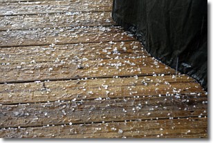
Sleet is a form of precipitation in which small ice pellets are the primary
components. These ice pellets are smaller and more translucent than hailstones,
and harder than graupel. Sleet is caused by specific atmospheric conditions and
therefore typically doesn't last for extended periods of time.
The condition which leads to sleet formation requires a warmer body of air to be
wedged in between two sub-freezing bodies of air. When snow falls through a warmer
layer of air it melts, and as it falls through the next sub-freezing body of air
it freezes again, forming ice pellets known as sleet. In some cases, water
droplets don't have time to freeze before reaching the surface and the result is
freezing rain.
Next Topic: Snow
Weather Topic: What are Stratocumulus Clouds?
Home - Education - Cloud Types - Stratocumulus Clouds
 Next Topic: Stratus Clouds
Stratocumulus clouds are similar to altocumulus clouds in their
fluffy appearance, but have a slightly darker shade due to their additional mass.
A good way to distinguish the two cloud types is to hold your hand out and measure
the size of an individual cloud; if it is the size of your thumb it is generally
an altocumulus cloud, if it is the size of your hand it is generally a
stratocumulus cloud.
It is uncommon for stratocumulus clouds to produce precipitation, but if they do
it is usually a light rain or snow.
Next Topic: Stratus Clouds
Current conditions powered by WeatherAPI.com


