Weather Alert in Alaska
Winter Weather Advisory issued February 24 at 2:07PM AKST until February 26 at 4:00PM AKST by NWS Juneau AK
AREAS AFFECTED: City and Borough of Sitka; Prince of Wales Island
DESCRIPTION: ...PERIODS OF SNOW THROUGH MID WEEK... .Light snow continuing in various inland areas this afternoon with around 2 to 4 inches already accumulated in Juneau and Petersburg. There should be a brief break in the snow tonight before more snow showers move in from the West Wednesday into Wednesday night. Snow accumulations will be highly variable Wednesday into Wednesday night with W to SW oriented slopes favored for higher snow totals. * WHAT...Snow expected. Total snow accumulations of 4 to 7 inches. Winds gusting as high as 35 mph. * WHERE...City and Borough of Sitka and Prince of Wales Island. * WHEN...From 6 PM Wednesday to 4 PM AKST Thursday. * IMPACTS...Travel could be very difficult. The hazardous conditions could impact the morning or evening commute. * ADDITIONAL DETAILS...Snow accumulations will be highly variable with localized locations having a chance of seeing accumulations a few inches higher or lower then the above range.
INSTRUCTION: Slow down and use caution while traveling. People are urged to prepare their property before the onset of winter weather. For the latest road conditions, where available, call 5 1 1 or visit 511.alaska.gov.
Want more detail? Get the Complete 7 Day and Night Detailed Forecast!
Current U.S. National Radar--Current
The Current National Weather Radar is shown below with a UTC Time (subtract 5 hours from UTC to get Eastern Time).

National Weather Forecast--Current
The Current National Weather Forecast and National Weather Map are shown below.

National Weather Forecast for Tomorrow
Tomorrow National Weather Forecast and Tomorrow National Weather Map are show below.

North America Water Vapor (Moisture)
This map shows recent moisture content over North America. Bright and colored areas show high moisture (ie, clouds); brown indicates very little moisture present; black indicates no moisture.

Weather Topic: What are Altostratus Clouds?
Home - Education - Cloud Types - Altostratus Clouds
 Next Topic: Cirrocumulus Clouds
Altostratus clouds form at mid to high-level altitudes
(between 2 and 7 km) and are created by a warm, stable air mass which causes
water vapor
to condense as it rise through the atmosphere. Usually altostratus clouds are
featureless sheets characterized by a uniform color.
In some cases, wind punching through the cloud formation may give it a waved
appearance, called altostratus undulatus. Altostratus clouds
are commonly seen with other cloud formations accompanying them.
Next Topic: Cirrocumulus Clouds
Weather Topic: What are Cirrostratus Clouds?
Home - Education - Cloud Types - Cirrostratus Clouds
 Next Topic: Cirrus Clouds
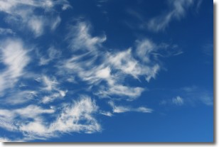
Cirrostratus clouds are high, thin clouds that form above
20,000 feet and are made mostly of ice crystals. They sometimes look like giant
feathers, horse tails, or curls of hair in the sky.
These clouds are pushed by the jet stream and can move at high speeds reaching
100 mph.
What do they indicate?
They indicate that a precipitation is likely within 24 hours.
Next Topic: Cirrus Clouds
Current conditions powered by WeatherAPI.com


