Weather Alert in Utah
Winter Weather Advisory issued March 4 at 12:26PM MST until March 6 at 5:00PM MST by NWS Salt Lake City UT
AREAS AFFECTED: Wasatch Mountains I-80 North; Wasatch Mountains South of I-80; Western Uinta Mountains
DESCRIPTION: * WHAT...Snow expected. Total snow accumulations 6 to 12 inches, locally up to 18 inches Cottonwoods. * WHERE...The Wasatch Mountains, and Western Uinta Mountains. * WHEN...From 2 AM Thursday to 5 PM MST Friday. * IMPACTS...Winter driving conditions are expected, including the Cottonwood Canyons, Logan Summit and Parley's Canyon. * ADDITIONAL DETAILS...A strong cold front will bring a period of moderate to heavy snow after midnight through 10 AM Thursday. After a brief break, snow showers will redevelop after 2 PM Thursday and continue into Friday afternoon. Storm total accumulation is a sum of both events.
INSTRUCTION: Slow down and use caution while traveling. For winter road conditions from the Utah Department of Transportation, visit http://www.udottraffic.utah.gov. For graphical depictions of the snowfall forecast, including Official NWS Forecast, High End Amount, and Low End Amount, visit weather.gov/slc/winter.
Want more detail? Get the Complete 7 Day and Night Detailed Forecast!
Current U.S. National Radar--Current
The Current National Weather Radar is shown below with a UTC Time (subtract 5 hours from UTC to get Eastern Time).

National Weather Forecast--Current
The Current National Weather Forecast and National Weather Map are shown below.

National Weather Forecast for Tomorrow
Tomorrow National Weather Forecast and Tomorrow National Weather Map are show below.

North America Water Vapor (Moisture)
This map shows recent moisture content over North America. Bright and colored areas show high moisture (ie, clouds); brown indicates very little moisture present; black indicates no moisture.

Weather Topic: What are Altostratus Clouds?
Home - Education - Cloud Types - Altostratus Clouds
 Next Topic: Cirrocumulus Clouds
Altostratus clouds form at mid to high-level altitudes
(between 2 and 7 km) and are created by a warm, stable air mass which causes
water vapor
to condense as it rise through the atmosphere. Usually altostratus clouds are
featureless sheets characterized by a uniform color.
In some cases, wind punching through the cloud formation may give it a waved
appearance, called altostratus undulatus. Altostratus clouds
are commonly seen with other cloud formations accompanying them.
Next Topic: Cirrocumulus Clouds
Weather Topic: What are Cirrostratus Clouds?
Home - Education - Cloud Types - Cirrostratus Clouds
 Next Topic: Cirrus Clouds
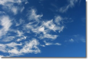
Cirrostratus clouds are high, thin clouds that form above
20,000 feet and are made mostly of ice crystals. They sometimes look like giant
feathers, horse tails, or curls of hair in the sky.
These clouds are pushed by the jet stream and can move at high speeds reaching
100 mph.
What do they indicate?
They indicate that a precipitation is likely within 24 hours.
Next Topic: Cirrus Clouds
Current conditions powered by WeatherAPI.com


