Weather Alert in Texas
Flood Advisory issued April 24 at 10:11AM CDT until April 24 at 12:00PM CDT by NWS San Angelo TX
AREAS AFFECTED: Callahan, TX; Coke, TX; Coleman, TX; Nolan, TX; Runnels, TX; Taylor, TX
DESCRIPTION: * WHAT...Flooding caused by excessive rainfall continues. * WHERE...A portion of west central Texas, including the following counties, Callahan, Coke, Coleman, Nolan, Runnels and Taylor. * WHEN...Until noon CDT. * IMPACTS...Minor flooding in low-lying and poor drainage areas. * ADDITIONAL DETAILS... - At 1009 AM CDT, Doppler radar indicated heavy rain due to thunderstorms from Ovalo to Crews to Goldsboro and Oplin moving east around 20 mph. Minor flooding is ongoing or expected to begin shortly in the advisory area. Between 0.75 and 2.5 inches of rain have fallen. - Additional rainfall amounts of 0.5 to 1 inch are expected over the area. This additional rain will result in minor flooding. - Some locations that will experience flooding include... Abilene, Blackwell, Nolan, Tuscola, Buffalo Gap, Lawn, Coronados Camp, Bradshaw, Happy Valley, View, Wingate, Hylton, Potosi, Dudley, Oplin, Eula, Lake Abilene, Camp Tonkawa, Drasco and Shep. - This includes the following Low Water Crossings... FM 1170 crossing Eagle Creek, FM 89 crossing Elm Creek, Craig Street at Catclaw Creek, FM 89 crossing Scott Hollow, FM 89 crossing Elm Creek, FM 1086 crossing Red Lake Creek, County Road 482 crossing Jim Ned Creek, County Road 241 crossing North Prong Pecan Bayou, County Road 244 crossing North Prong Pecan Bayou and County Road 482 crossing South Fork Jim Ned Creek. - http://www.weather.gov/safety/flood
INSTRUCTION: Turn around, don't drown when encountering flooded roads. Most flood deaths occur in vehicles. Be aware of your surroundings and do not drive on flooded roads. Stay away or be swept away. River banks and culverts can become unstable and unsafe.
Want more detail? Get the Complete 7 Day and Night Detailed Forecast!
Current U.S. National Radar--Current
The Current National Weather Radar is shown below with a UTC Time (subtract 5 hours from UTC to get Eastern Time).

National Weather Forecast--Current
The Current National Weather Forecast and National Weather Map are shown below.

National Weather Forecast for Tomorrow
Tomorrow National Weather Forecast and Tomorrow National Weather Map are show below.

North America Water Vapor (Moisture)
This map shows recent moisture content over North America. Bright and colored areas show high moisture (ie, clouds); brown indicates very little moisture present; black indicates no moisture.

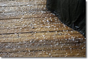
Weather Topic: What is Sleet?
Home - Education - Precipitation - Sleet
 Next Topic: Snow
Sleet is a form of precipitation in which small ice pellets are the primary
components. These ice pellets are smaller and more translucent than hailstones,
and harder than graupel. Sleet is caused by specific atmospheric conditions and
therefore typically doesn't last for extended periods of time.
The condition which leads to sleet formation requires a warmer body of air to be
wedged in between two sub-freezing bodies of air. When snow falls through a warmer
layer of air it melts, and as it falls through the next sub-freezing body of air
it freezes again, forming ice pellets known as sleet. In some cases, water
droplets don't have time to freeze before reaching the surface and the result is
freezing rain.
Next Topic: Snow
Weather Topic: What are Stratocumulus Clouds?
Home - Education - Cloud Types - Stratocumulus Clouds
 Next Topic: Stratus Clouds
Stratocumulus clouds are similar to altocumulus clouds in their
fluffy appearance, but have a slightly darker shade due to their additional mass.
A good way to distinguish the two cloud types is to hold your hand out and measure
the size of an individual cloud; if it is the size of your thumb it is generally
an altocumulus cloud, if it is the size of your hand it is generally a
stratocumulus cloud.
It is uncommon for stratocumulus clouds to produce precipitation, but if they do
it is usually a light rain or snow.
Next Topic: Stratus Clouds
Current conditions powered by WeatherAPI.com


