Weather Alert in Virginia
Winter Weather Advisory issued March 2 at 6:39AM EST until March 3 at 7:00AM EST by NWS Baltimore MD/Washington DC
AREAS AFFECTED: Western Highland; Eastern Highland; Western Grant; Eastern Grant; Western Pendleton; Eastern Pendleton
DESCRIPTION: * WHAT...Mixed precipitation expected. Total snow accumulations of 1 to 3 inches and ice accumulations up to two tenths of an inch. The highest amounts will be along the ridges. * WHERE...Portions of western Virginia and eastern West Virginia. * WHEN...From 10 AM this morning to 7 AM EST Tuesday. * IMPACTS...Plan on slippery road conditions. The hazardous conditions could impact the Monday evening and Tuesday morning commutes. * ADDITIONAL DETAILS...A period of snow is expected from late this morning into this afternoon. There may some breaks during the late afternoon and early evening before a wintry mix of snow, sleet, and then primarily freezing rain affects the area tonight. Precipitation will gradually change to plain rain and taper off Tuesday morning.
INSTRUCTION: Slow down and use caution while traveling. The latest road conditions for the state you are calling from can be obtained by calling 5 1 1.
Want more detail? Get the Complete 7 Day and Night Detailed Forecast!
Current U.S. National Radar--Current
The Current National Weather Radar is shown below with a UTC Time (subtract 5 hours from UTC to get Eastern Time).

National Weather Forecast--Current
The Current National Weather Forecast and National Weather Map are shown below.

National Weather Forecast for Tomorrow
Tomorrow National Weather Forecast and Tomorrow National Weather Map are show below.

North America Water Vapor (Moisture)
This map shows recent moisture content over North America. Bright and colored areas show high moisture (ie, clouds); brown indicates very little moisture present; black indicates no moisture.

Weather Topic: What is Condensation?
Home - Education - Precipitation - Condensation
 Next Topic: Contrails
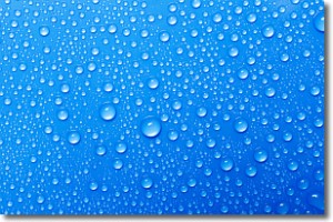
Condensation is the process which creates clouds, and therefore
it is a crucial process in the water cycle.
Condensation is the change of matter from a state of gas into a state of liquid,
and it happens because water molecules release heat into the atmosphere and
become organized into a more closely packed structure, what we might see as
water droplets.
Water is always present in the air around us as a vapor, but it's too small for
us to see. When water undergoes the process of condensation it becomes organized
into visible water droplets. You've probably seen condensation happen before on the
surface of a cold drink!
Next Topic: Contrails
Weather Topic: What are Cumulonimbus Clouds?
Home - Education - Cloud Types - Cumulonimbus Clouds
 Next Topic: Cumulus Clouds
The final form taken by a growing cumulus cloud is the
cumulonimbus cloud, which is very tall and dense.
The tower of a cumulonimbus cloud can soar 23 km into the atmosphere, although
most commonly they stop growing at an altitude of 6 km.
Even small cumulonimbus clouds appear very large in comparison to other cloud types.
They can signal the approach of stormy weather, such as thunderstorms or blizzards.
Next Topic: Cumulus Clouds
Current conditions powered by WeatherAPI.com


