Weather Alert in Oregon
Air Quality Alert issued August 22 at 10:49AM PDT by NWS Portland OR
AREAS AFFECTED: Tualatin Valley; West Hills and Chehalem Mountains; Inner Portland Metro; East Portland Metro; West Central Willamette Valley; East Central Willamette Valley; Benton County Lowlands; Linn County Lowlands; Lane County Lowlands
DESCRIPTION: The Oregon Department of Environmental Quality, and the Lane Regional Air Protection Agency has issued an Air Quality Advisory, which is IN EFFECT FROM 10 AM SATURDAY TO 8 PM PDT MONDAY. An Air Quality Advisory for Ozone has been issued. High levels of ozone in the lower atmosphere in the region combined with forecasted conditions will cause air quality to reach unhealthy levels at times through Monday evening. Pollutants can cause burning eyes, runny nose, aggravate heart and lung diseases, and aggravate other serious health problems. Limit outdoor activities and keep children indoors. Please follow medical advice if you have a heart or lung condition. More information about air quality can be found at: www.orcaa.org www.swcleanair.gov www.oregon.gov/DEQ www.lrapa.org
INSTRUCTION: N/A
Want more detail? Get the Complete 7 Day and Night Detailed Forecast!
Current U.S. National Radar--Current
The Current National Weather Radar is shown below with a UTC Time (subtract 5 hours from UTC to get Eastern Time).

National Weather Forecast--Current
The Current National Weather Forecast and National Weather Map are shown below.

National Weather Forecast for Tomorrow
Tomorrow National Weather Forecast and Tomorrow National Weather Map are show below.

North America Water Vapor (Moisture)
This map shows recent moisture content over North America. Bright and colored areas show high moisture (ie, clouds); brown indicates very little moisture present; black indicates no moisture.

Weather Topic: What is Sleet?
Home - Education - Precipitation - Sleet
 Next Topic: Snow
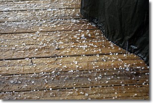
Sleet is a form of precipitation in which small ice pellets are the primary
components. These ice pellets are smaller and more translucent than hailstones,
and harder than graupel. Sleet is caused by specific atmospheric conditions and
therefore typically doesn't last for extended periods of time.
The condition which leads to sleet formation requires a warmer body of air to be
wedged in between two sub-freezing bodies of air. When snow falls through a warmer
layer of air it melts, and as it falls through the next sub-freezing body of air
it freezes again, forming ice pellets known as sleet. In some cases, water
droplets don't have time to freeze before reaching the surface and the result is
freezing rain.
Next Topic: Snow
Weather Topic: What are Stratocumulus Clouds?
Home - Education - Cloud Types - Stratocumulus Clouds
 Next Topic: Stratus Clouds
Stratocumulus clouds are similar to altocumulus clouds in their
fluffy appearance, but have a slightly darker shade due to their additional mass.
A good way to distinguish the two cloud types is to hold your hand out and measure
the size of an individual cloud; if it is the size of your thumb it is generally
an altocumulus cloud, if it is the size of your hand it is generally a
stratocumulus cloud.
It is uncommon for stratocumulus clouds to produce precipitation, but if they do
it is usually a light rain or snow.
Next Topic: Stratus Clouds
Current conditions powered by WeatherAPI.com


