Weather Alert in Illinois
Flood Warning issued August 19 at 7:35PM CDT until August 20 at 2:00PM CDT by NWS Chicago IL
AREAS AFFECTED: Will, IL
DESCRIPTION: ...The Flood Warning is extended for the following rivers in Illinois... East Branch Du Page River at Bolingbrook affecting Will and DuPage Counties. Du Page River at Shorewood affecting Will County. For the East Branch Du Page River...including Bolingbrook...Minor flooding is forecast. * WHAT...Minor flooding is occurring and minor flooding is forecast. * WHERE...Du Page River from IL-59 in Plainfield downstream to confluence with Des Plaines River, including the Shorewood gauge. * WHEN...Until early tomorrow afternoon. * IMPACTS...At 16.0 feet, Clark Drive threatened in Shorewood. * ADDITIONAL DETAILS... - At 6:45 PM CDT Tuesday the stage was 15.9 feet. - Recent Activity...The maximum river stage in the 24 hours ending at 6:45 PM CDT Tuesday was 15.9 feet. - Forecast...The river is expected to fall below flood stage tomorrow morning and continue falling to 11.2 feet Tuesday, August 26. - Flood stage is 15.5 feet. - http://www.weather.gov/safety/flood
INSTRUCTION: A Flood Warning means water levels above flood stage are imminent or may already be occurring. Persons along rivers and streams in the warned area should take immediate precautions to protect life and property. These forecasts are based on observed precipitation as well as forecast precipitation 24 hours into the future. Changes to the rainfall forecast, or any additional rainfall after 24 hours, may cause changes to these river forecasts. Additional information is available at www.weather.gov. The next statement will be issued by Wednesday morning.
Want more detail? Get the Complete 7 Day and Night Detailed Forecast!
Current U.S. National Radar--Current
The Current National Weather Radar is shown below with a UTC Time (subtract 5 hours from UTC to get Eastern Time).

National Weather Forecast--Current
The Current National Weather Forecast and National Weather Map are shown below.

National Weather Forecast for Tomorrow
Tomorrow National Weather Forecast and Tomorrow National Weather Map are show below.

North America Water Vapor (Moisture)
This map shows recent moisture content over North America. Bright and colored areas show high moisture (ie, clouds); brown indicates very little moisture present; black indicates no moisture.

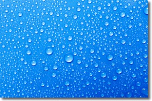
Weather Topic: What is Condensation?
Home - Education - Precipitation - Condensation
 Next Topic: Contrails
Condensation is the process which creates clouds, and therefore
it is a crucial process in the water cycle.
Condensation is the change of matter from a state of gas into a state of liquid,
and it happens because water molecules release heat into the atmosphere and
become organized into a more closely packed structure, what we might see as
water droplets.
Water is always present in the air around us as a vapor, but it's too small for
us to see. When water undergoes the process of condensation it becomes organized
into visible water droplets. You've probably seen condensation happen before on the
surface of a cold drink!
Next Topic: Contrails
Weather Topic: What are Cumulonimbus Clouds?
Home - Education - Cloud Types - Cumulonimbus Clouds
 Next Topic: Cumulus Clouds
The final form taken by a growing cumulus cloud is the
cumulonimbus cloud, which is very tall and dense.
The tower of a cumulonimbus cloud can soar 23 km into the atmosphere, although
most commonly they stop growing at an altitude of 6 km.
Even small cumulonimbus clouds appear very large in comparison to other cloud types.
They can signal the approach of stormy weather, such as thunderstorms or blizzards.
Next Topic: Cumulus Clouds
Current conditions powered by WeatherAPI.com


