Weather Alert in Alaska
Flood Warning issued August 26 at 11:05AM AKDT until August 27 at 11:00PM AKDT by NWS Fairbanks AK
AREAS AFFECTED: Central Brooks Range; South Slopes Of The Central Brooks Range; Upper Koyukuk Valley; Dalton Highway Summits
DESCRIPTION: * WHAT...Flooding caused by excessive rainfall is expected. * WHERE...Including the following areas, Central Brooks Range, Dalton Highway Summits, South Slopes Of The Central Brooks Range and Upper Koyukuk Valley. * WHEN...Until 1100 PM AKDT Wednesday. * IMPACTS...Flooding of rivers, creeks, streams, and other low-lying and flood-prone locations is imminent or occurring. * ADDITIONAL DETAILS... - At 1059 AM AKDT, River gauge reports indicate rises in water levels from heavy rain across the warned area. Flooding is ongoing or expected to begin shortly. Between 4 and 6 inches of rain have fallen. Additional rainfall amounts of 1 to 2 inches are possible. - Local reports of up to 18 inches of water is currently covering the road to Wiseman making that route impassable. In addition the stretch of the Dalton Highway from mile markers 140 to 240 have had numerous reports of water on the roadway or locations where the road is beginning to wash out. Numerous landslides have also been reported by the public near Wiseman along steep slopes in the area. - For Slate Creek at Coldfoot: At 10:15am the stage was 20.3 feet. Flood Stage is 18.7 feet. Forecast: A crest around 19.4 feet is expected around 4:00pm Tuesday. - http://www.weather.gov/aprfc
INSTRUCTION: Stay tuned to further developments by listening to your local radio, television, or NOAA Weather Radio for further information.
Want more detail? Get the Complete 7 Day and Night Detailed Forecast!
Current U.S. National Radar--Current
The Current National Weather Radar is shown below with a UTC Time (subtract 5 hours from UTC to get Eastern Time).

National Weather Forecast--Current
The Current National Weather Forecast and National Weather Map are shown below.

National Weather Forecast for Tomorrow
Tomorrow National Weather Forecast and Tomorrow National Weather Map are show below.

North America Water Vapor (Moisture)
This map shows recent moisture content over North America. Bright and colored areas show high moisture (ie, clouds); brown indicates very little moisture present; black indicates no moisture.

Weather Topic: What is Hail?
Home - Education - Precipitation - Hail
 Next Topic: Hole Punch Clouds
Hail is a form of precipitation which is recognized by large solid balls or
clumps of ice. Hail is created by thunderstorm clouds with strong updrafts of wind.
As the hailstones remain in the updraft, ice is deposited onto them until their
weight becomes heavy enough for them to fall to the earth's surface.
Hail storms can cause significant damage to crops, aircrafts, and man-made structures,
despite the fact that the duration is usually less than ten minutes.
Next Topic: Hole Punch Clouds
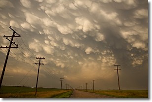
Weather Topic: What are Mammatus Clouds?
Home - Education - Cloud Types - Mammatus Clouds
 Next Topic: Nimbostratus Clouds
A mammatus cloud is a cloud with a unique feature which resembles
a web of pouches hanging along the base of the cloud.
In the United States, mammatus clouds tend to form in the warmer months, commonly
in the Midwest and eastern regions.
While they usually form at the bottom of a cumulonimbis cloud, they can also form
under altostratus, altocumulus, stratocumulus, and cirrus clouds. Mammatus clouds
warn that severe weather is close.
Next Topic: Nimbostratus Clouds
Current conditions powered by WeatherAPI.com


