Weather Alert in Colorado
Winter Storm Warning Winter Weather Advisory
High Wind Watch issued February 18 at 12:34AM MST until February 19 at 7:00AM MST by NWS Pueblo CO
AREAS AFFECTED: Teller County/Rampart Range above 7500fT/Pike's Peak Between 7500 And 11000 Ft; Pikes Peak above 11000 Ft; Northern El Paso County/Monument Ridge/Rampart Range Below 7500 Ft; Colorado Springs Vicinity/Southern El Paso County/Rampart Range Below 7400 Ft
DESCRIPTION: * WHAT...West winds 30 to 40 mph with gusts up to 70 mph possible. * WHERE...Teller County and the Rampart Range including Pikes Peak, and western El Paso county. * WHEN...From this evening through Thursday morning. * IMPACTS...Damaging winds could blow down trees and power lines, leading to possible power outages. Travel could be difficult, especially for high profile vehicles. * ADDITIONAL DETAILS...Strong downslope winds will be possible in the lee of the Rampart Range and Pikes Peak region tonight.
INSTRUCTION: Monitor the latest forecasts and warnings for updates.
Want more detail? Get the Complete 7 Day and Night Detailed Forecast!
Current U.S. National Radar--Current
The Current National Weather Radar is shown below with a UTC Time (subtract 5 hours from UTC to get Eastern Time).

National Weather Forecast--Current
The Current National Weather Forecast and National Weather Map are shown below.

National Weather Forecast for Tomorrow
Tomorrow National Weather Forecast and Tomorrow National Weather Map are show below.

North America Water Vapor (Moisture)
This map shows recent moisture content over North America. Bright and colored areas show high moisture (ie, clouds); brown indicates very little moisture present; black indicates no moisture.

Weather Topic: What are Cirrostratus Clouds?
Home - Education - Cloud Types - Cirrostratus Clouds
 Next Topic: Cirrus Clouds
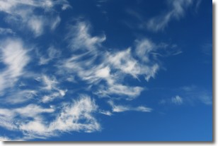
Cirrostratus clouds are high, thin clouds that form above
20,000 feet and are made mostly of ice crystals. They sometimes look like giant
feathers, horse tails, or curls of hair in the sky.
These clouds are pushed by the jet stream and can move at high speeds reaching
100 mph.
What do they indicate?
They indicate that a precipitation is likely within 24 hours.
Next Topic: Cirrus Clouds
Weather Topic: What is Condensation?
Home - Education - Precipitation - Condensation
 Next Topic: Contrails
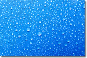
Condensation is the process which creates clouds, and therefore
it is a crucial process in the water cycle.
Condensation is the change of matter from a state of gas into a state of liquid,
and it happens because water molecules release heat into the atmosphere and
become organized into a more closely packed structure, what we might see as
water droplets.
Water is always present in the air around us as a vapor, but it's too small for
us to see. When water undergoes the process of condensation it becomes organized
into visible water droplets. You've probably seen condensation happen before on the
surface of a cold drink!
Next Topic: Contrails
Current conditions powered by WeatherAPI.com


