Weather Alert in New York
Coastal Flood Advisory issued August 20 at 3:53PM EDT until August 22 at 1:00PM EDT by NWS Upton NY
AREAS AFFECTED: Southwest Suffolk; Southern Nassau
DESCRIPTION: * WHAT...For the High Rip Current Risk, life-threatening rip currents. For the High Surf Advisory, large breaking waves building to 12 to 16 ft through Thursday night, subsiding to and 8 to 12 feet on Friday. For the Coastal Flood Warning, 2 to 2 1/2 feet of inundation above ground level expected in vulnerable areas near the waterfront and shoreline. For the first and second Coastal Flood Advisories, 1 to 2 ft of inundation above ground level likely. * WHERE...Southwest Suffolk and Southern Nassau Counties. * WHEN...For the High Surf Advisory, until 8 PM EDT Friday. For the High Rip Current Risk, through Friday evening. For the Coastal Flood Warning, from 5 PM Thursday to 1 AM EDT Friday. For the first Coastal Flood Advisory, from 5 AM to 1 PM EDT Friday. For the second Coastal Flood Advisory, from 6 PM Friday to 2 AM EDT Saturday. * COASTAL FLOOD IMPACTS...Widespread moderate flooding of vulnerable areas near the waterfront and shoreline with Thursday evening's high tide. Expect 2 to 2 1/2 ft of inundation above ground level in low lying, vulnerable areas. This will result in numerous road closures and cause widespread flooding of low lying property including parking lots, parks, lawns and homes/businesses with basements near the waterfront. Vehicles parked in vulnerable areas near the waterfront will likely become flooded. * SWIMMING IMPACTS...Life-threatening swimming and surfing conditions and localized beach erosion. Life-threatening rip currents are likely for all people entering the surf zone. Anyone visiting the beaches should stay out of the surf. Rip currents can sweep even the best swimmers away from shore into deeper water. * SHORELINE IMPACTS...The threat for dune erosion and beach flooding will increase with successive high tides thru Fri morning. Widespread areas of dune erosion with localized overwashes are expected during the Thu evening and Fri morning high tides.
INSTRUCTION: Take the necessary actions to protect flood-prone property. If travel is required, do not drive around barricades or through water of unknown depth. Inexperienced swimmers should remain out of the water due to dangerous surf conditions. If you enter the surf zone, always have a flotation device with you and swim near a lifeguard. If caught in a rip current, relax and float, and do not swim against the current. If able, swim in a direction following the shoreline. If unable to escape, face the shore and yell or wave for help.
Want more detail? Get the Complete 7 Day and Night Detailed Forecast!
Current U.S. National Radar--Current
The Current National Weather Radar is shown below with a UTC Time (subtract 5 hours from UTC to get Eastern Time).

National Weather Forecast--Current
The Current National Weather Forecast and National Weather Map are shown below.

National Weather Forecast for Tomorrow
Tomorrow National Weather Forecast and Tomorrow National Weather Map are show below.

North America Water Vapor (Moisture)
This map shows recent moisture content over North America. Bright and colored areas show high moisture (ie, clouds); brown indicates very little moisture present; black indicates no moisture.

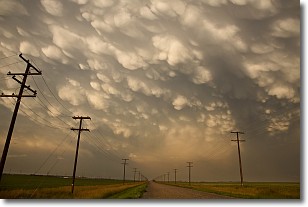
Weather Topic: What are Mammatus Clouds?
Home - Education - Cloud Types - Mammatus Clouds
 Next Topic: Nimbostratus Clouds
A mammatus cloud is a cloud with a unique feature which resembles
a web of pouches hanging along the base of the cloud.
In the United States, mammatus clouds tend to form in the warmer months, commonly
in the Midwest and eastern regions.
While they usually form at the bottom of a cumulonimbis cloud, they can also form
under altostratus, altocumulus, stratocumulus, and cirrus clouds. Mammatus clouds
warn that severe weather is close.
Next Topic: Nimbostratus Clouds
Weather Topic: What is Precipitation?
Home - Education - Precipitation - Precipitation
 Next Topic: Rain
Precipitation can refer to many different forms of water that
may fall from clouds. Precipitation occurs after a cloud has become saturated to
the point where its water particles are more dense than the air below the cloud.
In most cases, precipitation will reach the ground, but it is not uncommon for
precipitation to evaporate before it reaches the earth's surface.
When precipitation evaporates before it contacts the ground it is called Virga.
Graupel, hail, sleet, rain, drizzle, and snow are forms of precipitation, but fog
and mist are not considered precipitation because the water vapor which
constitutes them isn't dense enough to fall to the ground.
Next Topic: Rain
Current conditions powered by WeatherAPI.com


