Weather Alert in California
Winter Storm Warning issued February 18 at 2:32PM PST until February 19 at 10:00AM PST by NWS Medford OR
AREAS AFFECTED: Western Siskiyou County
DESCRIPTION: ...ANOTHER EPISODE OF LOW ELEVATION SNOW LATE TONIGHT INTO THURSDAY... .Scattered to numerous light snow showers will persist through this evening with snow levels around 1500 to 2000 feet and accumulation of up to 2 inches. The next cold front will follow with widespread accumulations of snow late tonight into Thursday morning and snow levels around 1000 to 1500 feet. Light snow showers will then taper off into Thursday afternoon while snow levels rise to 2000 feet, except for snow showers lingering into Thursday evening for eastern Klamath, Lake, and Modoc Counties. * WHAT...Heavy snow. Additional snow accumulations 4 to 12 inches at elevations above 3000 feet and 1 to 5 inches at elevations below 3000 feet. Snow levels near 2000 feet will fall to valley floors overnight. A majority of the snow is expected between Midnight and 7 AM PST Thursday morning, with light snow showers then tapering off through the morning. * WHERE...In western Siskiyou County. This includes all of Highway 96 and 3, and Etna Summit on Sawyers Bar Rd. This also includes the Klamath River and Scott Valleys, the communities of Happy Camp, Somes Bar, Etna, Greenview, and Callahan. * WHEN...Until 10 AM PST Thursday. * IMPACTS...Travel may be very difficult to impossible. The hazardous conditions could impact the Thursday morning commute. * ADDITIONAL DETAILS... Visit weather.gov/mfr/winter for additional snow probabilities
INSTRUCTION: If you must travel, keep an extra flashlight, food, and water in your vehicle in case of an emergency. Call 511 or visit quickmap.dot.ca.gov for road information.
Want more detail? Get the Complete 7 Day and Night Detailed Forecast!
Current U.S. National Radar--Current
The Current National Weather Radar is shown below with a UTC Time (subtract 5 hours from UTC to get Eastern Time).

National Weather Forecast--Current
The Current National Weather Forecast and National Weather Map are shown below.

National Weather Forecast for Tomorrow
Tomorrow National Weather Forecast and Tomorrow National Weather Map are show below.

North America Water Vapor (Moisture)
This map shows recent moisture content over North America. Bright and colored areas show high moisture (ie, clouds); brown indicates very little moisture present; black indicates no moisture.

Weather Topic: What are Altostratus Clouds?
Home - Education - Cloud Types - Altostratus Clouds
 Next Topic: Cirrocumulus Clouds
Altostratus clouds form at mid to high-level altitudes
(between 2 and 7 km) and are created by a warm, stable air mass which causes
water vapor
to condense as it rise through the atmosphere. Usually altostratus clouds are
featureless sheets characterized by a uniform color.
In some cases, wind punching through the cloud formation may give it a waved
appearance, called altostratus undulatus. Altostratus clouds
are commonly seen with other cloud formations accompanying them.
Next Topic: Cirrocumulus Clouds
Weather Topic: What are Cirrostratus Clouds?
Home - Education - Cloud Types - Cirrostratus Clouds
 Next Topic: Cirrus Clouds
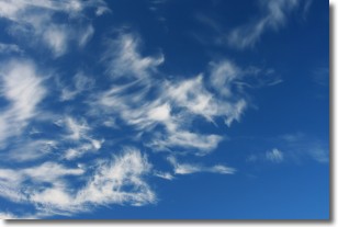
Cirrostratus clouds are high, thin clouds that form above
20,000 feet and are made mostly of ice crystals. They sometimes look like giant
feathers, horse tails, or curls of hair in the sky.
These clouds are pushed by the jet stream and can move at high speeds reaching
100 mph.
What do they indicate?
They indicate that a precipitation is likely within 24 hours.
Next Topic: Cirrus Clouds
Current conditions powered by WeatherAPI.com


