Weather Alert in North Carolina
High Surf Advisory issued August 20 at 7:37PM EDT until August 23 at 12:00AM EDT by NWS Newport/Morehead City NC
AREAS AFFECTED: Northern Outer Banks; Ocracoke Island; Hatteras Island
DESCRIPTION: * WHAT...For the Beach Hazards Statement, dangerous rip currents in the surf zone. For the High Surf Advisory, large breaking waves of 10 to 20+ feet in the surf zone. * WHERE...The beaches from Duck to Hatteras Island. * WHEN...For the Beach Hazards Statement, through Thursday evening. For the High Surf Advisory, until midnight EDT Friday night. * IMPACTS...Extreme beach and coastal damage is likely along the oceanside, resulting in a significant threat to life and property. Large dangerous waves will likely inundate and destroy protective dune structures. Severe flooding will likely extend inland from the waterfront causing flooding of many homes and businesses with some structural damage possible. Numerous roads will likely be impassable under several feet of water and vehicles will likely be submerged. Actions will need to be taken to protect life and property. Extremely dangerous swimming and surfing conditions expected, as well as the wave action resulting in significant beach erosion. * ADDITIONAL DETAILS...A Storm Surge Warning remains in effect for the Outer Banks. This is expected to be a prolonged duration event, with the potential for portions of NC-12 and secondary roads along the Outer Banks, in particular on Hatteras and Ocracoke Islands, to be impassable and/or inaccessible through the end of the week due to significant wave run up.
INSTRUCTION: Inexperienced swimmers should remain out of the water due to dangerous surf conditions. Life-threatening rip currents. If caught in a rip current, remain calm. Swim in a direction following the shoreline. If tired, float or tread water until out of the rip current. If unable to escape, face the shore and call or wave for help.
Want more detail? Get the Complete 7 Day and Night Detailed Forecast!
Current U.S. National Radar--Current
The Current National Weather Radar is shown below with a UTC Time (subtract 5 hours from UTC to get Eastern Time).

National Weather Forecast--Current
The Current National Weather Forecast and National Weather Map are shown below.

National Weather Forecast for Tomorrow
Tomorrow National Weather Forecast and Tomorrow National Weather Map are show below.

North America Water Vapor (Moisture)
This map shows recent moisture content over North America. Bright and colored areas show high moisture (ie, clouds); brown indicates very little moisture present; black indicates no moisture.

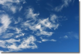
Weather Topic: What are Cirrostratus Clouds?
Home - Education - Cloud Types - Cirrostratus Clouds
 Next Topic: Cirrus Clouds
Cirrostratus clouds are high, thin clouds that form above
20,000 feet and are made mostly of ice crystals. They sometimes look like giant
feathers, horse tails, or curls of hair in the sky.
These clouds are pushed by the jet stream and can move at high speeds reaching
100 mph.
What do they indicate?
They indicate that a precipitation is likely within 24 hours.
Next Topic: Cirrus Clouds
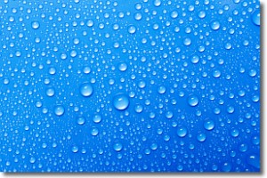
Weather Topic: What is Condensation?
Home - Education - Precipitation - Condensation
 Next Topic: Contrails
Condensation is the process which creates clouds, and therefore
it is a crucial process in the water cycle.
Condensation is the change of matter from a state of gas into a state of liquid,
and it happens because water molecules release heat into the atmosphere and
become organized into a more closely packed structure, what we might see as
water droplets.
Water is always present in the air around us as a vapor, but it's too small for
us to see. When water undergoes the process of condensation it becomes organized
into visible water droplets. You've probably seen condensation happen before on the
surface of a cold drink!
Next Topic: Contrails
Current conditions powered by WeatherAPI.com


