Weather Alert in New York
Extreme Cold Watch issued February 5 at 12:49AM EST until February 8 at 1:00PM EST by NWS Binghamton NY
AREAS AFFECTED: Northern Oneida; Yates; Seneca; Southern Cayuga; Onondaga; Steuben; Schuyler; Chemung; Tompkins; Madison; Southern Oneida; Cortland; Chenango; Otsego; Tioga; Broome; Delaware; Sullivan; Bradford; Susquehanna; Northern Wayne; Wyoming; Lackawanna; Luzerne; Pike; Southern Wayne
DESCRIPTION: * WHAT...Dangerous wind chills colder than 20 below zero possible. * WHERE...All of central New York and northeast Pennsylvania. * WHEN...From late Friday night through Sunday afternoon. * IMPACTS...The dangerously cold wind chills as low as 30 below zero could cause frostbite on exposed skin in as little as 30 minutes. Frostbite and hypothermia will occur if unprotected skin is exposed to these temperatures. * ADDITIONAL DETAILS...An arctic front will bring cold air and strong winds to the region Saturday morning. Below normal temperatures and blustery winds will result in wind chills dropping well below zero Saturday morning. Wind chills will remain below zero through the rest of the weekend.
INSTRUCTION: Dress in layers including a hat, face mask, and gloves if you must go outside. Keep pets indoors as much as possible. Monitor the latest forecasts and warnings for updates.
Want more detail? Get the Complete 7 Day and Night Detailed Forecast!
Current U.S. National Radar--Current
The Current National Weather Radar is shown below with a UTC Time (subtract 5 hours from UTC to get Eastern Time).

National Weather Forecast--Current
The Current National Weather Forecast and National Weather Map are shown below.

National Weather Forecast for Tomorrow
Tomorrow National Weather Forecast and Tomorrow National Weather Map are show below.

North America Water Vapor (Moisture)
This map shows recent moisture content over North America. Bright and colored areas show high moisture (ie, clouds); brown indicates very little moisture present; black indicates no moisture.

Weather Topic: What is Snow?
Home - Education - Precipitation - Snow
 Next Topic: Stratocumulus Clouds
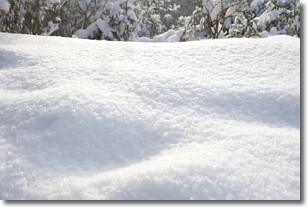
Snow is precipitation taking the form of ice crystals. Each ice crystal, or snowflake,
has unique characteristics, but all of them grow in a hexagonal structure.
Snowfall can last for sustained periods of time and result in significant buildup
of snow on the ground.
On the earth's surface, snow starts out light and powdery, but as it begins to melt
it tends to become more granular, producing small bits of ice which have the consistency of
sand. After several cycles of melting and freezing, snow can become very dense
and ice-like, commonly known as snow pack.
Next Topic: Stratocumulus Clouds
Weather Topic: What are Stratus Clouds?
Home - Education - Cloud Types - Stratus Clouds
 Next Topic: Wall Clouds
Stratus clouds are similar to altostratus clouds, but form at a
lower altitude and are identified by their fog-like appearance, lacking the
distinguishing features of most clouds.
Stratus clouds are wider than most clouds, and their base has a smooth, uniform
look which is lighter in color than a nimbostratus cloud.
The presence of a stratus cloud indicates the possibility of minor precipitation,
such as drizzle, but heavier precipitation does not typically arrive in the form
of a stratus cloud.
Next Topic: Wall Clouds
Current conditions powered by WeatherAPI.com


