Weather Alert in Oregon
Extreme Heat Watch issued August 20 at 1:59PM PDT until August 26 at 9:00PM PDT by NWS Pendleton OR
AREAS AFFECTED: Eastern Columbia River Gorge of Oregon; Lower Columbia Basin of Oregon; Foothills of the Northern Blue Mountains of Oregon; Foothills of the Southern Blue Mountains of Oregon; North Central Oregon; Eastern Columbia River Gorge of Washington; Kittitas Valley; Yakima Valley; Lower Columbia Basin of Washington; Foothills of the Blue Mountains of Washington; Simcoe Highlands; Lower Slopes of the Eastern Washington Cascades Crest
DESCRIPTION: * WHAT...Dangerously hot conditions with high temperatures of 95 to 105 degrees possible. This will pose a major to extreme risk of heat-related illness. * WHERE...Portions of north central and northeast Oregon and central, south central, and southeast Washington. * WHEN...From Saturday afternoon through Tuesday evening. * IMPACTS...Heat related illnesses increase significantly during extreme heat events. Extreme heat will significantly increase the risk of heat-related illnesses for much of the population, especially those who are heat sensitive and those without effective cooling or adequate hydration.
INSTRUCTION: Monitor the latest forecasts and warnings for updates on this situation. Be prepared to drink plenty of fluids, stay in an air-conditioned room, stay out of the sun, and check up on relatives and neighbors. Young children and pets should never be left unattended in vehicles under any circumstances. This is especially true during warm or hot weather when car interiors can reach lethal temperatures in a matter of minutes.
Want more detail? Get the Complete 7 Day and Night Detailed Forecast!
Current U.S. National Radar--Current
The Current National Weather Radar is shown below with a UTC Time (subtract 5 hours from UTC to get Eastern Time).

National Weather Forecast--Current
The Current National Weather Forecast and National Weather Map are shown below.

National Weather Forecast for Tomorrow
Tomorrow National Weather Forecast and Tomorrow National Weather Map are show below.

North America Water Vapor (Moisture)
This map shows recent moisture content over North America. Bright and colored areas show high moisture (ie, clouds); brown indicates very little moisture present; black indicates no moisture.

Weather Topic: What are Cumulonimbus Clouds?
Home - Education - Cloud Types - Cumulonimbus Clouds
 Next Topic: Cumulus Clouds
The final form taken by a growing cumulus cloud is the
cumulonimbus cloud, which is very tall and dense.
The tower of a cumulonimbus cloud can soar 23 km into the atmosphere, although
most commonly they stop growing at an altitude of 6 km.
Even small cumulonimbus clouds appear very large in comparison to other cloud types.
They can signal the approach of stormy weather, such as thunderstorms or blizzards.
Next Topic: Cumulus Clouds
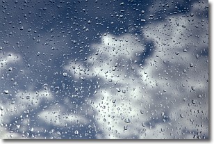
Weather Topic: What is Drizzle?
Home - Education - Precipitation - Drizzle
 Next Topic: Evaporation
Drizzle is precipitation in the form of water droplets which are
smaller than raindrops.
Drizzle is characterized by fine, gently falling droplets and typically does not
impact human habitation in a negative way. The exception to this is freezing drizzle,
a condition where drizzle freezes immediately upon reaching earth's surface.
Freezing drizzle is still less dangerous than freezing rain, but can
potentially result in hazardous road conditions.
Next Topic: Evaporation
Current conditions powered by WeatherAPI.com


