Weather Alert in North Carolina
Special Weather Statement issued February 4 at 11:13PM EST by NWS Morristown TN
AREAS AFFECTED: Cherokee; Clay; Scott; Campbell; Claiborne; Hancock; Hawkins; Sullivan; Johnson; Morgan; Anderson; Union; Grainger; Hamblen; Northwest Cocke; Cocke Smoky Mountains; Northwest Greene; Southeast Greene; Washington; Unicoi; Northwest Carter; Southeast Carter; Roane; Loudon; Knox; Jefferson; NW Blount; Blount Smoky Mountains; North Sevier; Sevier Smoky Mountains; Sequatchie; Bledsoe; Rhea; Meigs; McMinn; Northwest Monroe; Southeast Monroe; Marion; Hamilton; Bradley; West Polk; East Polk; Lee; Wise; Scott; Russell; Washington
DESCRIPTION: Light snow will bring minor snow accumulations across portions of the Northern Valley, Southwest Virginia, and the East Tennessee Mountains before tapering off after midnight. Most areas will see no more than a dusting to a few tenths of an inch, but up to an inch may occur in a few locations. In addition, temperatures will fall into the 20s area wide tonight. Any wet spots on roads from recent rain or melting snow will re- freeze and create black ice. Be prepared for slick spots overnight into Thursday morning, especially on untreated roadways. Use caution if traveling.
INSTRUCTION: N/A
Want more detail? Get the Complete 7 Day and Night Detailed Forecast!
Current U.S. National Radar--Current
The Current National Weather Radar is shown below with a UTC Time (subtract 5 hours from UTC to get Eastern Time).

National Weather Forecast--Current
The Current National Weather Forecast and National Weather Map are shown below.

National Weather Forecast for Tomorrow
Tomorrow National Weather Forecast and Tomorrow National Weather Map are show below.

North America Water Vapor (Moisture)
This map shows recent moisture content over North America. Bright and colored areas show high moisture (ie, clouds); brown indicates very little moisture present; black indicates no moisture.

Weather Topic: What is Hail?
Home - Education - Precipitation - Hail
 Next Topic: Hole Punch Clouds
Hail is a form of precipitation which is recognized by large solid balls or
clumps of ice. Hail is created by thunderstorm clouds with strong updrafts of wind.
As the hailstones remain in the updraft, ice is deposited onto them until their
weight becomes heavy enough for them to fall to the earth's surface.
Hail storms can cause significant damage to crops, aircrafts, and man-made structures,
despite the fact that the duration is usually less than ten minutes.
Next Topic: Hole Punch Clouds
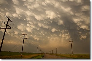
Weather Topic: What are Mammatus Clouds?
Home - Education - Cloud Types - Mammatus Clouds
 Next Topic: Nimbostratus Clouds
A mammatus cloud is a cloud with a unique feature which resembles
a web of pouches hanging along the base of the cloud.
In the United States, mammatus clouds tend to form in the warmer months, commonly
in the Midwest and eastern regions.
While they usually form at the bottom of a cumulonimbis cloud, they can also form
under altostratus, altocumulus, stratocumulus, and cirrus clouds. Mammatus clouds
warn that severe weather is close.
Next Topic: Nimbostratus Clouds
Current conditions powered by WeatherAPI.com


