Weather Alert in New York
Special Weather Statement issued September 3 at 3:07PM EDT by NWS Burlington VT
AREAS AFFECTED: Northern Franklin; Eastern Clinton; Western Clinton; Eastern Essex; Grand Isle; Western Franklin; Orleans; Essex; Western Chittenden; Lamoille; Caledonia; Washington; Western Addison; Orange; Western Rutland; Eastern Franklin; Eastern Chittenden; Eastern Addison; Eastern Rutland; Western Windsor; Eastern Windsor
DESCRIPTION: Fine fuels remain very dry across the area, particularly across the Connecticut and Champlain Valleys, according to the Vermont Department of Forests, Parks and Recreation and the New York State Department of Environmental Conservation. Portions of central and northern Vermont and parts of northern New York also remain in moderate drought. Southerly winds will quickly increase to 10 to 15 MPH with gusts up to 25 MPH possible across Vermont. Localized gusts up to 35 MPH are possible particularly in the north to south oriented valleys of the Champlain Valley and portions of northern New York. This, combined with expected low relative humidity values between 25% to 35% will create near critical fire weather conditions Thursday. Winds will be strongest between noon and 8 PM, coinciding with the timing of the minimum relative humidity values. If any fires were to start the weather and fuel conditions could cause fires to quickly get out of control and be difficult to contain. Fire weather conditions areawide will quickly improve as confidence increases in wetting rainfall Thursday night. For more information about the current fire danger rating, any burn restrictions, and wildfire prevention and education, please visit your state forestry or environmental protection website.
INSTRUCTION: N/A
Want more detail? Get the Complete 7 Day and Night Detailed Forecast!
Current U.S. National Radar--Current
The Current National Weather Radar is shown below with a UTC Time (subtract 5 hours from UTC to get Eastern Time).

National Weather Forecast--Current
The Current National Weather Forecast and National Weather Map are shown below.

National Weather Forecast for Tomorrow
Tomorrow National Weather Forecast and Tomorrow National Weather Map are show below.

North America Water Vapor (Moisture)
This map shows recent moisture content over North America. Bright and colored areas show high moisture (ie, clouds); brown indicates very little moisture present; black indicates no moisture.

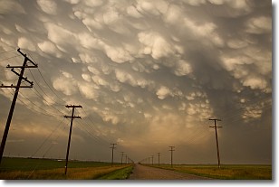
Weather Topic: What are Mammatus Clouds?
Home - Education - Cloud Types - Mammatus Clouds
 Next Topic: Nimbostratus Clouds
A mammatus cloud is a cloud with a unique feature which resembles
a web of pouches hanging along the base of the cloud.
In the United States, mammatus clouds tend to form in the warmer months, commonly
in the Midwest and eastern regions.
While they usually form at the bottom of a cumulonimbis cloud, they can also form
under altostratus, altocumulus, stratocumulus, and cirrus clouds. Mammatus clouds
warn that severe weather is close.
Next Topic: Nimbostratus Clouds
Weather Topic: What is Precipitation?
Home - Education - Precipitation - Precipitation
 Next Topic: Rain
Precipitation can refer to many different forms of water that
may fall from clouds. Precipitation occurs after a cloud has become saturated to
the point where its water particles are more dense than the air below the cloud.
In most cases, precipitation will reach the ground, but it is not uncommon for
precipitation to evaporate before it reaches the earth's surface.
When precipitation evaporates before it contacts the ground it is called Virga.
Graupel, hail, sleet, rain, drizzle, and snow are forms of precipitation, but fog
and mist are not considered precipitation because the water vapor which
constitutes them isn't dense enough to fall to the ground.
Next Topic: Rain
Current conditions powered by WeatherAPI.com


