Weather Alert in New York
Winter Storm Warning issued February 22 at 12:50PM EST until February 24 at 6:00AM EST by NWS Buffalo NY
AREAS AFFECTED: Chautauqua
DESCRIPTION: * WHAT...Heavy snow expected. Total snow accumulations 8 to 12 inches in a narrow band along the Chautauqua Ridge. Snow accumulations will be much lower along the Lake Erie shore and farther inland near Jamestown, where only 2 to 4 inches is expected. * WHERE...Chautauqua County. The greatest accumulations will focus in a narrow band along the Chautauqua Ridge. * WHEN...From 7 PM this evening to 6 AM EST Tuesday. The heaviest snowfall is expected late tonight through Monday afternoon. * IMPACTS...Travel will be difficult with snow covered roads and poor visibility at times. The hazardous conditions will impact the Monday morning and evening commutes.
INSTRUCTION: Widespread accumulating snow will create difficult travel conditions. Submit snow reports through our website or social media.
Want more detail? Get the Complete 7 Day and Night Detailed Forecast!
Current U.S. National Radar--Current
The Current National Weather Radar is shown below with a UTC Time (subtract 5 hours from UTC to get Eastern Time).

National Weather Forecast--Current
The Current National Weather Forecast and National Weather Map are shown below.

National Weather Forecast for Tomorrow
Tomorrow National Weather Forecast and Tomorrow National Weather Map are show below.

North America Water Vapor (Moisture)
This map shows recent moisture content over North America. Bright and colored areas show high moisture (ie, clouds); brown indicates very little moisture present; black indicates no moisture.

Weather Topic: What is Hail?
Home - Education - Precipitation - Hail
 Next Topic: Hole Punch Clouds
Hail is a form of precipitation which is recognized by large solid balls or
clumps of ice. Hail is created by thunderstorm clouds with strong updrafts of wind.
As the hailstones remain in the updraft, ice is deposited onto them until their
weight becomes heavy enough for them to fall to the earth's surface.
Hail storms can cause significant damage to crops, aircrafts, and man-made structures,
despite the fact that the duration is usually less than ten minutes.
Next Topic: Hole Punch Clouds
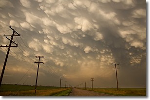
Weather Topic: What are Mammatus Clouds?
Home - Education - Cloud Types - Mammatus Clouds
 Next Topic: Nimbostratus Clouds
A mammatus cloud is a cloud with a unique feature which resembles
a web of pouches hanging along the base of the cloud.
In the United States, mammatus clouds tend to form in the warmer months, commonly
in the Midwest and eastern regions.
While they usually form at the bottom of a cumulonimbis cloud, they can also form
under altostratus, altocumulus, stratocumulus, and cirrus clouds. Mammatus clouds
warn that severe weather is close.
Next Topic: Nimbostratus Clouds
Current conditions powered by WeatherAPI.com


