Weather Alert in Colorado
Fire Weather Watch issued March 25 at 5:55PM MDT until March 26 at 6:00PM MDT by NWS Goodland KS
AREAS AFFECTED: Kit Carson County; Cheyenne; Sherman; Thomas; Sheridan; Graham; Wallace; Logan; Gove; Greeley; Wichita
DESCRIPTION: ...Critical Fire Weather South of I-70 Thursday Afternoon... .On Thursday, well above normal temperatures and dry conditions will persist south of Interstate 70, where light northeasterly winds during the late morning and early afternoon will abruptly increase to 20 to 30 mph with gusts up to 45 mph during the late afternoon. * AFFECTED AREA...Fire Weather Zones 013 Sherman, 014 Thomas, 015 Sheridan, 016 Graham, 027 Wallace, 028 Logan, 029 Gove, 041 Greeley, 042 Wichita, 253 Kit Carson and 254 Cheyenne CO. * TIMING...From Thursday morning through Thursday afternoon. * WINDS...Northeast at 10 to 15 mph during the late morning and early afternoon, abruptly increasing to 20 to 30 mph with gusts up to 45 mph during the late afternoon. * RELATIVE HUMIDITY...As low as 15 percent. * IMPACTS...Unpredictable fire behavior. Any fires that develop may rapidly grow and spread out of control.
INSTRUCTION: A Fire Weather Watch means that critical fire weather conditions are forecast to occur. Listen for later forecasts and possible red flag warnings.
Want more detail? Get the Complete 7 Day and Night Detailed Forecast!
Current U.S. National Radar--Current
The Current National Weather Radar is shown below with a UTC Time (subtract 5 hours from UTC to get Eastern Time).

National Weather Forecast--Current
The Current National Weather Forecast and National Weather Map are shown below.

National Weather Forecast for Tomorrow
Tomorrow National Weather Forecast and Tomorrow National Weather Map are show below.

North America Water Vapor (Moisture)
This map shows recent moisture content over North America. Bright and colored areas show high moisture (ie, clouds); brown indicates very little moisture present; black indicates no moisture.

Weather Topic: What is Sleet?
Home - Education - Precipitation - Sleet
 Next Topic: Snow
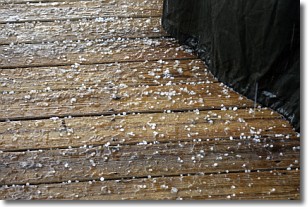
Sleet is a form of precipitation in which small ice pellets are the primary
components. These ice pellets are smaller and more translucent than hailstones,
and harder than graupel. Sleet is caused by specific atmospheric conditions and
therefore typically doesn't last for extended periods of time.
The condition which leads to sleet formation requires a warmer body of air to be
wedged in between two sub-freezing bodies of air. When snow falls through a warmer
layer of air it melts, and as it falls through the next sub-freezing body of air
it freezes again, forming ice pellets known as sleet. In some cases, water
droplets don't have time to freeze before reaching the surface and the result is
freezing rain.
Next Topic: Snow
Weather Topic: What are Stratocumulus Clouds?
Home - Education - Cloud Types - Stratocumulus Clouds
 Next Topic: Stratus Clouds
Stratocumulus clouds are similar to altocumulus clouds in their
fluffy appearance, but have a slightly darker shade due to their additional mass.
A good way to distinguish the two cloud types is to hold your hand out and measure
the size of an individual cloud; if it is the size of your thumb it is generally
an altocumulus cloud, if it is the size of your hand it is generally a
stratocumulus cloud.
It is uncommon for stratocumulus clouds to produce precipitation, but if they do
it is usually a light rain or snow.
Next Topic: Stratus Clouds
Current conditions powered by WeatherAPI.com


