Weather Alert in North Carolina
Flood Advisory issued May 21 at 6:54AM EDT until May 21 at 10:00AM EDT by NWS Blacksburg VA
AREAS AFFECTED: Caswell, NC; Rockingham, NC; Charlotte, VA; Halifax, VA; Pittsylvania, VA; City of Danville, VA
DESCRIPTION: * WHAT...Flooding caused by excessive rainfall is expected. * WHERE...Portions of north central North Carolina, including the following counties, Caswell and Rockingham and south central Virginia, including the following counties and independent city, Charlotte, City of Danville, Halifax and Pittsylvania. * WHEN...Until 1000 AM EDT. * IMPACTS...Minor flooding in low-lying and poor drainage areas. Ponding of water in urban or other areas is occurring or is imminent. * ADDITIONAL DETAILS... - At 654 AM EDT, Doppler radar indicated heavy rain. Minor flooding is ongoing or expected to begin shortly in the advisory area. Between 2 and 3 inches of rain have fallen. - This includes the following streams and drainages... Allen Creek, Bales Spring Branch, Ballous Creek, Aarons Creek, Banister River and Armistead Branch. Additional rainfall amounts of 0.5 to 1.5 inches are expected over the area. This additional rain will result in minor flooding. - Some locations that will experience flooding include... Danville... Reidsville... South Boston... Wentworth... Yanceyville... Bethel... Halifax... - http://www.weather.gov/safety/flood
INSTRUCTION: Turn around, don't drown when encountering flooded roads. Most flood deaths occur in vehicles. When it is safe to do so, please send your reports of flooding, including mudslides or flooded roads, to the National Weather Service by calling toll free at 1...8 6 6...2 1 5...4 3 2 4. Reports and pictures can also be shared on the National Weather Service Blacksburg Facebook page and on Twitter.
Want more detail? Get the Complete 7 Day and Night Detailed Forecast!
Current U.S. National Radar--Current
The Current National Weather Radar is shown below with a UTC Time (subtract 5 hours from UTC to get Eastern Time).

National Weather Forecast--Current
The Current National Weather Forecast and National Weather Map are shown below.

National Weather Forecast for Tomorrow
Tomorrow National Weather Forecast and Tomorrow National Weather Map are show below.

North America Water Vapor (Moisture)
This map shows recent moisture content over North America. Bright and colored areas show high moisture (ie, clouds); brown indicates very little moisture present; black indicates no moisture.

Weather Topic: What are Altostratus Clouds?
Home - Education - Cloud Types - Altostratus Clouds
 Next Topic: Cirrocumulus Clouds
Altostratus clouds form at mid to high-level altitudes
(between 2 and 7 km) and are created by a warm, stable air mass which causes
water vapor
to condense as it rise through the atmosphere. Usually altostratus clouds are
featureless sheets characterized by a uniform color.
In some cases, wind punching through the cloud formation may give it a waved
appearance, called altostratus undulatus. Altostratus clouds
are commonly seen with other cloud formations accompanying them.
Next Topic: Cirrocumulus Clouds
Weather Topic: What are Cirrostratus Clouds?
Home - Education - Cloud Types - Cirrostratus Clouds
 Next Topic: Cirrus Clouds
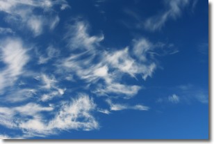
Cirrostratus clouds are high, thin clouds that form above
20,000 feet and are made mostly of ice crystals. They sometimes look like giant
feathers, horse tails, or curls of hair in the sky.
These clouds are pushed by the jet stream and can move at high speeds reaching
100 mph.
What do they indicate?
They indicate that a precipitation is likely within 24 hours.
Next Topic: Cirrus Clouds
Current conditions powered by WeatherAPI.com


