Weather Alert in Washington
Red Flag Warning issued August 27 at 9:21AM PDT until August 27 at 8:00PM PDT by NWS Seattle WA
AREAS AFFECTED: West Slopes of the North Cascades Generally above 1500 Feet; West Slopes of the Central Cascades Generally above 1500 Feet; East Portion of the Olympic Mountains
DESCRIPTION: * AFFECTED AREA...Fire Weather Zone 658 West Slopes of the North Cascades Generally above 1500 Feet, Fire Weather Zone 659 West Slopes of the Central Cascades Generally above 1500 Feet and Fire Weather Zone 661 East Portion of the Olympic Mountains. * THUNDERSTORMS...Thunderstorms are favored along the eastern slopes of the Olympic mountains between 11 AM and 3 PM, and more so in the Cascades from 3 PM to 8 PM. Wetting rains are possible, but lightning strikes on very dry fuel are capable of new fire starts. * OUTFLOW WINDS...Outflow winds of 25 to 30 mph are possible. Outflow winds can occur ahead of and behind storms and cause erratic wind directions. * IMPACTS...Scattered lightning in dry fuels can cause multiple fire starts. Thunderstorms can also bring sudden sharp wind shifts on existing fires, causing rapid changes in a fire's rate of spread and direction of spread. Thunderstorm outflow winds can be a threat for several hours following the start of a new lightning-caused fire. If a fire were to begin, air quality may diminish in the surrounding area. * THUNDERSTORMS...Multiple lightning strikes occurred in the higher terrain of the Cascades mountains yesterday afternoon and evening and that will resume this afternoon and evening. Multiple days in a row of lightning strikes on our dry fuels could result in a critical number of new wildfires.
INSTRUCTION: A Red Flag Warning means that critical fire weather conditions are either imminent or occurring now. Any fires that develop will likely spread quickly. Outdoor burning is not recommended.
Want more detail? Get the Complete 7 Day and Night Detailed Forecast!
Current U.S. National Radar--Current
The Current National Weather Radar is shown below with a UTC Time (subtract 5 hours from UTC to get Eastern Time).

National Weather Forecast--Current
The Current National Weather Forecast and National Weather Map are shown below.

National Weather Forecast for Tomorrow
Tomorrow National Weather Forecast and Tomorrow National Weather Map are show below.

North America Water Vapor (Moisture)
This map shows recent moisture content over North America. Bright and colored areas show high moisture (ie, clouds); brown indicates very little moisture present; black indicates no moisture.

Weather Topic: What is Precipitation?
Home - Education - Precipitation - Precipitation
 Next Topic: Rain
Precipitation can refer to many different forms of water that
may fall from clouds. Precipitation occurs after a cloud has become saturated to
the point where its water particles are more dense than the air below the cloud.
In most cases, precipitation will reach the ground, but it is not uncommon for
precipitation to evaporate before it reaches the earth's surface.
When precipitation evaporates before it contacts the ground it is called Virga.
Graupel, hail, sleet, rain, drizzle, and snow are forms of precipitation, but fog
and mist are not considered precipitation because the water vapor which
constitutes them isn't dense enough to fall to the ground.
Next Topic: Rain
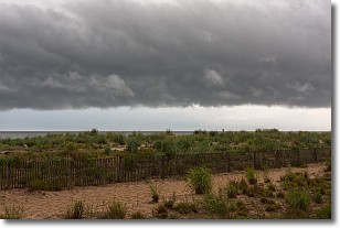
Weather Topic: What are Shelf Clouds?
Home - Education - Cloud Types - Shelf Clouds
 Next Topic: Sleet
A shelf cloud is similar to a wall cloud, but forms at the front
of a storm cloud, instead of at the rear, where wall clouds form.
A shelf cloud is caused by a series of events set into motion by the advancing
storm; first, cool air settles along the ground where precipitation has just fallen.
As the cool air is brought in, the warmer air is displaced, and rises above it,
because it is less dense. When the warmer air reaches the bottom of the storm cloud,
it begins to cool again, and the resulting condensation is a visible shelf cloud.
Next Topic: Sleet
Current conditions powered by WeatherAPI.com


