Weather Alert in Wisconsin
Winter Storm Warning issued April 2 at 6:59AM CDT until April 2 at 12:00PM CDT by NWS Twin Cities/Chanhassen MN
AREAS AFFECTED: Polk; Barron; Rusk; St. Croix; Pierce; Dunn; Pepin
DESCRIPTION: ...MESSY SPRING SYSTEM BRINGS FREEZING RAIN, SLEET, AND SNOW THROUGH THIS MORNING... .Western and central Minnesota will experience mainly slushy wet snow with accumulations of 2 to 4 inches, meanwhile rain is favored in southern and southeastern Minnesota. In between the snow and rain, a messy wintry mix of sleet and freezing rain will result in ice accumulations and slippery travel. There is still a moderate degree of uncertainty regarding ice accumulation amounts, due to temperatures being very close to freezing and a fluctuation of only a degree or two likely having a large impact on final amounts. The greatest impacts from icing and freezing rain will occur over western Wisconsin and east-central Minnesota, with accumulations up to a quarter inch in Minnesota and a few tenths of an inch in Wisconsin. Power outages are possible due to icing of power lines in addition to gusty winds, and slippery to impossible travel will occur where ice accumulates. Slow travel from wet slushy snow is expected in western and central Minnesota. * WHAT...Heavy mixed precipitation. Additional snow accumulations up to one inch, sleet accumulations between one tenth and two tenths of an inch, and ice accumulations up to one tenth of an inch. * WHERE...Barron, Polk, Rusk, Dunn, Pepin, Pierce, and St. Croix Counties. * WHEN...Until noon CDT today. * IMPACTS...Roads, and especially bridges and overpasses, will likely become slick and hazardous. Significant ice accumulation on power lines and tree limbs may cause widespread and long-lasting power outages. Plan on slippery road conditions. The hazardous conditions will impact the Thursday morning commute.
INSTRUCTION: If you must travel, keep an extra flashlight, food, and water in your vehicle in case of an emergency. Call 5 1 1 or visit 511wi.gov for road conditions. Persons should consider delaying all travel. If travel is absolutely necessary, drive with extreme caution. Consider taking a winter storm kit along with you, including such items as tire chains, booster cables, flashlight, shovel, blankets and extra clothing. Also take water, a first aid kit, and anything else that would help you survive in case you become stranded.
Want more detail? Get the Complete 7 Day and Night Detailed Forecast!
Current U.S. National Radar--Current
The Current National Weather Radar is shown below with a UTC Time (subtract 5 hours from UTC to get Eastern Time).

National Weather Forecast--Current
The Current National Weather Forecast and National Weather Map are shown below.

National Weather Forecast for Tomorrow
Tomorrow National Weather Forecast and Tomorrow National Weather Map are show below.

North America Water Vapor (Moisture)
This map shows recent moisture content over North America. Bright and colored areas show high moisture (ie, clouds); brown indicates very little moisture present; black indicates no moisture.

Weather Topic: What are Altostratus Clouds?
Home - Education - Cloud Types - Altostratus Clouds
 Next Topic: Cirrocumulus Clouds
Altostratus clouds form at mid to high-level altitudes
(between 2 and 7 km) and are created by a warm, stable air mass which causes
water vapor
to condense as it rise through the atmosphere. Usually altostratus clouds are
featureless sheets characterized by a uniform color.
In some cases, wind punching through the cloud formation may give it a waved
appearance, called altostratus undulatus. Altostratus clouds
are commonly seen with other cloud formations accompanying them.
Next Topic: Cirrocumulus Clouds
Weather Topic: What are Cirrostratus Clouds?
Home - Education - Cloud Types - Cirrostratus Clouds
 Next Topic: Cirrus Clouds
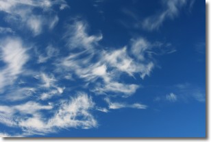
Cirrostratus clouds are high, thin clouds that form above
20,000 feet and are made mostly of ice crystals. They sometimes look like giant
feathers, horse tails, or curls of hair in the sky.
These clouds are pushed by the jet stream and can move at high speeds reaching
100 mph.
What do they indicate?
They indicate that a precipitation is likely within 24 hours.
Next Topic: Cirrus Clouds
Current conditions powered by WeatherAPI.com


