Weather Alert in Minnesota
Winter Weather Advisory issued April 2 at 6:59AM CDT until April 2 at 10:00AM CDT by NWS Twin Cities/Chanhassen MN
AREAS AFFECTED: Sherburne; Isanti; Chisago; Wright; Anoka; Renville; McLeod; Sibley; Redwood; Brown; Nicollet; Watonwan; Blue Earth; Waseca; Steele
DESCRIPTION: ...MESSY SPRING SYSTEM BRINGS FREEZING RAIN, SLEET, AND SNOW THROUGH THIS MORNING... .Western and central Minnesota will experience mainly slushy wet snow with accumulations of 2 to 4 inches, meanwhile rain is favored in southern and southeastern Minnesota. In between the snow and rain, a messy wintry mix of sleet and freezing rain will result in ice accumulations and slippery travel. There is still a moderate degree of uncertainty regarding ice accumulation amounts, due to temperatures being very close to freezing and a fluctuation of only a degree or two likely having a large impact on final amounts. The greatest impacts from icing and freezing rain will occur over western Wisconsin and east-central Minnesota, with accumulations up to a quarter inch in Minnesota and a few tenths of an inch in Wisconsin. Power outages are possible due to icing of power lines in addition to gusty winds, and slippery to impossible travel will occur where ice accumulates. Slow travel from wet slushy snow is expected in western and central Minnesota. * WHAT...Mixed precipitation. Additional snow accumulations up to one inch, sleet accumulations up to one tenth of an inch, and ice accumulations around a light glaze. * WHERE...McLeod, Renville, Sherburne, Sibley, Wright, Anoka, Chisago, Isanti, Blue Earth, Brown, Nicollet, Steele, Waseca, Watonwan, and Redwood Counties. * WHEN...Until 10 AM CDT this morning. * IMPACTS...Plan on slippery road conditions. The hazardous conditions will impact the Thursday morning commute.
INSTRUCTION: Slow down and use caution while traveling. Call 5 1 1 or visit 511mn.org for road conditions. Be prepared for slippery roads. Slow down and use caution while driving. If you are going outside, watch your first few steps taken on stairs, sidewalks, and driveways. These surfaces could be icy and slippery, increasing your risk of a fall and injury.
Want more detail? Get the Complete 7 Day and Night Detailed Forecast!
Current U.S. National Radar--Current
The Current National Weather Radar is shown below with a UTC Time (subtract 5 hours from UTC to get Eastern Time).

National Weather Forecast--Current
The Current National Weather Forecast and National Weather Map are shown below.

National Weather Forecast for Tomorrow
Tomorrow National Weather Forecast and Tomorrow National Weather Map are show below.

North America Water Vapor (Moisture)
This map shows recent moisture content over North America. Bright and colored areas show high moisture (ie, clouds); brown indicates very little moisture present; black indicates no moisture.

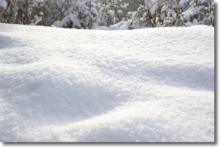
Weather Topic: What is Snow?
Home - Education - Precipitation - Snow
 Next Topic: Stratocumulus Clouds
Snow is precipitation taking the form of ice crystals. Each ice crystal, or snowflake,
has unique characteristics, but all of them grow in a hexagonal structure.
Snowfall can last for sustained periods of time and result in significant buildup
of snow on the ground.
On the earth's surface, snow starts out light and powdery, but as it begins to melt
it tends to become more granular, producing small bits of ice which have the consistency of
sand. After several cycles of melting and freezing, snow can become very dense
and ice-like, commonly known as snow pack.
Next Topic: Stratocumulus Clouds
Weather Topic: What are Stratus Clouds?
Home - Education - Cloud Types - Stratus Clouds
 Next Topic: Wall Clouds
Stratus clouds are similar to altostratus clouds, but form at a
lower altitude and are identified by their fog-like appearance, lacking the
distinguishing features of most clouds.
Stratus clouds are wider than most clouds, and their base has a smooth, uniform
look which is lighter in color than a nimbostratus cloud.
The presence of a stratus cloud indicates the possibility of minor precipitation,
such as drizzle, but heavier precipitation does not typically arrive in the form
of a stratus cloud.
Next Topic: Wall Clouds
Current conditions powered by WeatherAPI.com


