Weather Alert in Arizona
Dust Storm Warning issued August 25 at 4:41PM MST until August 25 at 5:45PM MST by NWS Phoenix AZ
AREAS AFFECTED: Maricopa, AZ; Pinal, AZ
DESCRIPTION: The National Weather Service in Phoenix has issued a * Dust Storm Warning for... Maricopa County in south central Arizona... Pinal County in southeastern Arizona... * Until 545 PM MST. * At 441 PM MST, a wall of dust was along a line extending from near Freeman to near Olberg to near Magma, moving northwest at 30 mph. HAZARD...Near zero visibility with strong wind in excess of 50 mph. SOURCE...Trained weather spotters. IMPACT...Dangerous life-threatening travel. * This includes the following highways... AZ Interstate 10 between mile markers 129 and 178. AZ Interstate 17 between mile markers 195 and 202. AZ Route 51 between mile markers 1 and 3. Locations impacted include... Phoenix, Mesa, Chandler, Gilbert, Tempe, Avondale, Goodyear, Apache Junction, Tolleson, Laveen, Cashion, East Mesa, Gold Canyon, Sun Lakes, and Maricopa.
INSTRUCTION: Dust storms lead to dangerous driving conditions with visibility reduced to near zero. If driving, avoid dust storms if possible. If caught in one, pull off the road, turn off your lights and keep your foot off the brake.
Want more detail? Get the Complete 7 Day and Night Detailed Forecast!
Current U.S. National Radar--Current
The Current National Weather Radar is shown below with a UTC Time (subtract 5 hours from UTC to get Eastern Time).

National Weather Forecast--Current
The Current National Weather Forecast and National Weather Map are shown below.

National Weather Forecast for Tomorrow
Tomorrow National Weather Forecast and Tomorrow National Weather Map are show below.

North America Water Vapor (Moisture)
This map shows recent moisture content over North America. Bright and colored areas show high moisture (ie, clouds); brown indicates very little moisture present; black indicates no moisture.

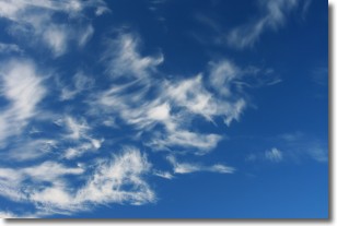
Weather Topic: What are Cirrostratus Clouds?
Home - Education - Cloud Types - Cirrostratus Clouds
 Next Topic: Cirrus Clouds
Cirrostratus clouds are high, thin clouds that form above
20,000 feet and are made mostly of ice crystals. They sometimes look like giant
feathers, horse tails, or curls of hair in the sky.
These clouds are pushed by the jet stream and can move at high speeds reaching
100 mph.
What do they indicate?
They indicate that a precipitation is likely within 24 hours.
Next Topic: Cirrus Clouds
Weather Topic: What is Condensation?
Home - Education - Precipitation - Condensation
 Next Topic: Contrails
Condensation is the process which creates clouds, and therefore
it is a crucial process in the water cycle.
Condensation is the change of matter from a state of gas into a state of liquid,
and it happens because water molecules release heat into the atmosphere and
become organized into a more closely packed structure, what we might see as
water droplets.
Water is always present in the air around us as a vapor, but it's too small for
us to see. When water undergoes the process of condensation it becomes organized
into visible water droplets. You've probably seen condensation happen before on the
surface of a cold drink!
Next Topic: Contrails
Current conditions powered by WeatherAPI.com


