Weather Alert in Illinois
Flood Watch issued July 26 at 4:22AM CDT until July 26 at 7:00PM CDT by NWS Chicago IL
AREAS AFFECTED: Ogle; Lee; De Kalb; Kane; DuPage; La Salle; Kendall; Grundy; Northern Cook; Central Cook; Southern Cook; Northern Will; Southern Will; Eastern Will; Lake
DESCRIPTION: * WHAT...Flash flooding caused by excessive rainfall continues to be possible. * WHERE...Portions of Illinois, including the following areas, Cook, De Kalb, DuPage, Will, Grundy, Kane, Kendall, La Salle, Lee, Ogle,and northwest Indiana, including the following area, Lake IN. * WHEN...Through this evening. * IMPACTS...Creeks and streams may rise out of their banks. Flooding may occur in poor drainage and urban areas. Underpasses may be flooded. Roads and streets may be flooded. Storm drains and ditches may be clogged with debris, increasing the risk of flooding. Additionally, flooding of basements may occur if thunderstorms train over urban areas. * ADDITIONAL DETAILS... - Additional waves of showers and thunderstorms will move into northeast Illinois, including over areas that experienced several inches of rain yesterday. The tropical-like airmass will support rain rates in excess of 2 inches per hour in the strongest thunderstorms, leading to a threat for flash flooding. - http://www.weather.gov/safety/flood
INSTRUCTION: Monitor the latest forecasts and be prepared to take quick action should flooding develop.
Want more detail? Get the Complete 7 Day and Night Detailed Forecast!
Current U.S. National Radar--Current
The Current National Weather Radar is shown below with a UTC Time (subtract 5 hours from UTC to get Eastern Time).

National Weather Forecast--Current
The Current National Weather Forecast and National Weather Map are shown below.

National Weather Forecast for Tomorrow
Tomorrow National Weather Forecast and Tomorrow National Weather Map are show below.

North America Water Vapor (Moisture)
This map shows recent moisture content over North America. Bright and colored areas show high moisture (ie, clouds); brown indicates very little moisture present; black indicates no moisture.

Weather Topic: What is Condensation?
Home - Education - Precipitation - Condensation
 Next Topic: Contrails
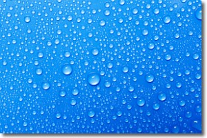
Condensation is the process which creates clouds, and therefore
it is a crucial process in the water cycle.
Condensation is the change of matter from a state of gas into a state of liquid,
and it happens because water molecules release heat into the atmosphere and
become organized into a more closely packed structure, what we might see as
water droplets.
Water is always present in the air around us as a vapor, but it's too small for
us to see. When water undergoes the process of condensation it becomes organized
into visible water droplets. You've probably seen condensation happen before on the
surface of a cold drink!
Next Topic: Contrails
Weather Topic: What are Cumulonimbus Clouds?
Home - Education - Cloud Types - Cumulonimbus Clouds
 Next Topic: Cumulus Clouds
The final form taken by a growing cumulus cloud is the
cumulonimbus cloud, which is very tall and dense.
The tower of a cumulonimbus cloud can soar 23 km into the atmosphere, although
most commonly they stop growing at an altitude of 6 km.
Even small cumulonimbus clouds appear very large in comparison to other cloud types.
They can signal the approach of stormy weather, such as thunderstorms or blizzards.
Next Topic: Cumulus Clouds
Current conditions powered by WeatherAPI.com


