Weather Alert in Massachusetts
Coastal Flood Watch issued February 22 at 3:17AM EST until February 23 at 8:00PM EST by NWS Boston/Norton MA
AREAS AFFECTED: Eastern Plymouth; Barnstable; Dukes; Nantucket
DESCRIPTION: * WHAT...For the Coastal Flood Warning, two to three feet of inundation above ground level expected in low-lying areas near shorelines and tidal waterways (4.5 to 13.5 feet Mean Lower Low Water). For the Coastal Flood Watch, one to two feet of inundation above ground level possible in low-lying areas near shorelines and tidal waterways (3.6 to 13.7 feet Mean Lower Low Water). * WHERE...Eastern Plymouth, Barnstable, Dukes and Nantucket Counties. * WHEN...For the Coastal Flood Warning, from 1 AM to 7 AM EST Monday. For the Coastal Flood Watch, from Monday afternoon through Monday evening. * IMPACTS...Many roads near Nantucket Harbor become impassable with 1 to 2 feet of water and affects access to the ferry terminals. This includes Easy Street, South Beach Street, Easton Street, Walsh Street, Willard Street, and Straight Wharf. Many coastal roads become impassable with flooding 1 to 3 feet deep. This includes the Chappy Ferry Dock and Dock Street near Edgartown Harbor. In Vineyard Haven, Five Corners, Beach Road, and Water Street become impassable. In Oak Bluffs, flooding affects East Chop Drive, the section of Lake Avenue near Oak Bluffs Harbor, and Sea View Avenue, where debris may also wash onto the roadway.
INSTRUCTION: Take the necessary actions to protect flood-prone property. If travel is required, do not drive around barricades or through water of unknown depth.
Want more detail? Get the Complete 7 Day and Night Detailed Forecast!
Current U.S. National Radar--Current
The Current National Weather Radar is shown below with a UTC Time (subtract 5 hours from UTC to get Eastern Time).

National Weather Forecast--Current
The Current National Weather Forecast and National Weather Map are shown below.

National Weather Forecast for Tomorrow
Tomorrow National Weather Forecast and Tomorrow National Weather Map are show below.

North America Water Vapor (Moisture)
This map shows recent moisture content over North America. Bright and colored areas show high moisture (ie, clouds); brown indicates very little moisture present; black indicates no moisture.

Weather Topic: What is Precipitation?
Home - Education - Precipitation - Precipitation
 Next Topic: Rain
Precipitation can refer to many different forms of water that
may fall from clouds. Precipitation occurs after a cloud has become saturated to
the point where its water particles are more dense than the air below the cloud.
In most cases, precipitation will reach the ground, but it is not uncommon for
precipitation to evaporate before it reaches the earth's surface.
When precipitation evaporates before it contacts the ground it is called Virga.
Graupel, hail, sleet, rain, drizzle, and snow are forms of precipitation, but fog
and mist are not considered precipitation because the water vapor which
constitutes them isn't dense enough to fall to the ground.
Next Topic: Rain
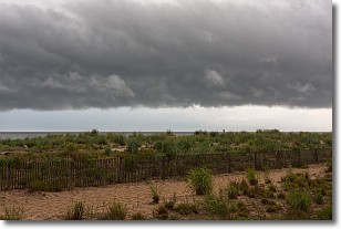
Weather Topic: What are Shelf Clouds?
Home - Education - Cloud Types - Shelf Clouds
 Next Topic: Sleet
A shelf cloud is similar to a wall cloud, but forms at the front
of a storm cloud, instead of at the rear, where wall clouds form.
A shelf cloud is caused by a series of events set into motion by the advancing
storm; first, cool air settles along the ground where precipitation has just fallen.
As the cool air is brought in, the warmer air is displaced, and rises above it,
because it is less dense. When the warmer air reaches the bottom of the storm cloud,
it begins to cool again, and the resulting condensation is a visible shelf cloud.
Next Topic: Sleet
Current conditions powered by WeatherAPI.com


