Weather Alert in Minnesota
Air Quality Alert issued July 22 at 2:51PM CDT by NWS Grand Forks ND
AREAS AFFECTED: West Polk; Kittson; Roseau; Lake Of The Woods; West Marshall; East Marshall; North Beltrami; Pennington; Red Lake; East Polk; North Clearwater
DESCRIPTION: * WHAT...The Minnesota Pollution Control Agency has issued an Air Quality Alert for fine particles pollution. The Air Quality Index (AQI) is expected to reach the Red or Unhealthy category. * WHERE...Northwest Minnesota. * WHEN...From 6 AM CDT Wednesday to 11 PM CDT Friday. * IMPACTS...Some members of the general public may experience health effects. Sensitive groups, such as people with lung disease (including asthma), heart disease, and children and older adults, may experience health effects. * ADDITIONAL DETAILS...A band of heavy smoke from wildfires in Saskatchewan and Manitoba is moving south across southern Manitoba and will reach northwest Minnesota by early Wednesday morning. A stationary front will remain over the northern part of the state for most of the day Wednesday, which will keep ground-level smoke confined to the northwest corner of the state. The front will move east and exit the region overnight and by Thursday morning northwest winds will be widespread across the state. This will allow smoke to move quickly southeast and smoke will reach northeast, central, and southwest Minnesota by Thursday afternoon. The alert will likely need to be expanded for Thursday. Air quality impacts will continue through Friday. Winds will become southerly Friday, which will push the smoke back to the north. Air quality should improve gradually from south to north beginning Friday afternoon.
INSTRUCTION: Sensitive groups, such as people with lung disease (including asthma), heart disease, and children and older adults, should avoid prolonged or heavy exertion. The general public should limit prolonged or heavy exertion. Reduce or eliminate activities that contribute to air pollution, such as outdoor burning, and use of residential wood burning devices. Reduce vehicle trips and vehicle idling as much as possible. Keep windows closed overnight to prevent smoke from getting indoors.
Want more detail? Get the Complete 7 Day and Night Detailed Forecast!
Current U.S. National Radar--Current
The Current National Weather Radar is shown below with a UTC Time (subtract 5 hours from UTC to get Eastern Time).

National Weather Forecast--Current
The Current National Weather Forecast and National Weather Map are shown below.

National Weather Forecast for Tomorrow
Tomorrow National Weather Forecast and Tomorrow National Weather Map are show below.

North America Water Vapor (Moisture)
This map shows recent moisture content over North America. Bright and colored areas show high moisture (ie, clouds); brown indicates very little moisture present; black indicates no moisture.

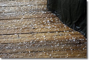
Weather Topic: What is Sleet?
Home - Education - Precipitation - Sleet
 Next Topic: Snow
Sleet is a form of precipitation in which small ice pellets are the primary
components. These ice pellets are smaller and more translucent than hailstones,
and harder than graupel. Sleet is caused by specific atmospheric conditions and
therefore typically doesn't last for extended periods of time.
The condition which leads to sleet formation requires a warmer body of air to be
wedged in between two sub-freezing bodies of air. When snow falls through a warmer
layer of air it melts, and as it falls through the next sub-freezing body of air
it freezes again, forming ice pellets known as sleet. In some cases, water
droplets don't have time to freeze before reaching the surface and the result is
freezing rain.
Next Topic: Snow
Weather Topic: What are Stratocumulus Clouds?
Home - Education - Cloud Types - Stratocumulus Clouds
 Next Topic: Stratus Clouds
Stratocumulus clouds are similar to altocumulus clouds in their
fluffy appearance, but have a slightly darker shade due to their additional mass.
A good way to distinguish the two cloud types is to hold your hand out and measure
the size of an individual cloud; if it is the size of your thumb it is generally
an altocumulus cloud, if it is the size of your hand it is generally a
stratocumulus cloud.
It is uncommon for stratocumulus clouds to produce precipitation, but if they do
it is usually a light rain or snow.
Next Topic: Stratus Clouds
Current conditions powered by WeatherAPI.com


