Weather Alert in California
Heat Advisory issued May 30 at 8:48AM PDT until May 30 at 8:00PM PDT by NWS Los Angeles/Oxnard CA
AREAS AFFECTED: Cuyama Valley; Santa Clarita Valley; Southern Salinas Valley; San Luis Obispo County Interior Valleys; San Luis Obispo County Mountains; Central Ventura County Valleys; Western San Fernando Valley; Eastern San Fernando Valley
DESCRIPTION: * WHAT...High temperatures from 92 to 102 expected. * WHERE...Central Ventura County Valleys, Cuyama Valley, Eastern San Fernando Valley, San Luis Obispo County Interior Valleys, San Luis Obispo County Mountains, Santa Clarita Valley, Southern Salinas Valley, and Western San Fernando Valley. * WHEN...Until 8 PM PDT this evening. * IMPACTS...There is a high risk for heat illness for sensitive populations including the very young, the very old, those without air conditioning, and those active outdoors (including hikers).
INSTRUCTION: Drink plenty of fluids, stay in an air-conditioned room, stay out of the sun, and check up on relatives and neighbors. Take extra precautions when outside. Wear lightweight and loose fitting clothing. Limit strenuous activities to early morning or evening. Take action when you see symptoms of heat exhaustion and heat stroke.
Want more detail? Get the Complete 7 Day and Night Detailed Forecast!
Current U.S. National Radar--Current
The Current National Weather Radar is shown below with a UTC Time (subtract 5 hours from UTC to get Eastern Time).

National Weather Forecast--Current
The Current National Weather Forecast and National Weather Map are shown below.

National Weather Forecast for Tomorrow
Tomorrow National Weather Forecast and Tomorrow National Weather Map are show below.

North America Water Vapor (Moisture)
This map shows recent moisture content over North America. Bright and colored areas show high moisture (ie, clouds); brown indicates very little moisture present; black indicates no moisture.

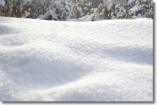
Weather Topic: What is Snow?
Home - Education - Precipitation - Snow
 Next Topic: Stratocumulus Clouds
Snow is precipitation taking the form of ice crystals. Each ice crystal, or snowflake,
has unique characteristics, but all of them grow in a hexagonal structure.
Snowfall can last for sustained periods of time and result in significant buildup
of snow on the ground.
On the earth's surface, snow starts out light and powdery, but as it begins to melt
it tends to become more granular, producing small bits of ice which have the consistency of
sand. After several cycles of melting and freezing, snow can become very dense
and ice-like, commonly known as snow pack.
Next Topic: Stratocumulus Clouds
Weather Topic: What are Stratus Clouds?
Home - Education - Cloud Types - Stratus Clouds
 Next Topic: Wall Clouds
Stratus clouds are similar to altostratus clouds, but form at a
lower altitude and are identified by their fog-like appearance, lacking the
distinguishing features of most clouds.
Stratus clouds are wider than most clouds, and their base has a smooth, uniform
look which is lighter in color than a nimbostratus cloud.
The presence of a stratus cloud indicates the possibility of minor precipitation,
such as drizzle, but heavier precipitation does not typically arrive in the form
of a stratus cloud.
Next Topic: Wall Clouds
Current conditions powered by WeatherAPI.com


