Weather Alert in Ohio
Flash Flood Warning issued July 1 at 10:09AM EDT until July 1 at 12:15PM EDT by NWS Wilmington OH
AREAS AFFECTED: Miami, OH
DESCRIPTION: FFWILN The National Weather Service in Wilmington has issued a * Flash Flood Warning for... Southwestern Miami County in west central Ohio... * Until 1215 PM EDT. * At 1009 AM EDT, radar and automated rain gauges indicated thunderstorms producing heavy rain across the warned area. Between 1.5 and 2 inches of rain have fallen. The expected rainfall rate is 1 to 1.5 inches in 1 hour. Additional rainfall amounts of 1 to 1.5 inches are possible. Flash flooding is ongoing or expected to begin shortly. HAZARD...Flash flooding caused by thunderstorms. SOURCE...Radar and automated gauges. IMPACT...Flash flooding of small creeks and streams, urban areas, highways, streets and underpasses as well as other poor drainage and low-lying areas. * Some locations that may experience flash flooding include... West Milton, Pleasant Hill, Clayton, Union, Laura, Potsdam, Ludlow Falls and Garland. This area has already received heavy rain earlier this morning.
INSTRUCTION: Turn around, don't drown when encountering flooded roads. Most flood deaths occur in vehicles. Stay away or be swept away. River banks and culverts can become unstable and unsafe. To report flash flooding, go to our website at weather.gov/iln and submit your report via social media, when you can do so safely.
Want more detail? Get the Complete 7 Day and Night Detailed Forecast!
Current U.S. National Radar--Current
The Current National Weather Radar is shown below with a UTC Time (subtract 5 hours from UTC to get Eastern Time).

National Weather Forecast--Current
The Current National Weather Forecast and National Weather Map are shown below.

National Weather Forecast for Tomorrow
Tomorrow National Weather Forecast and Tomorrow National Weather Map are show below.

North America Water Vapor (Moisture)
This map shows recent moisture content over North America. Bright and colored areas show high moisture (ie, clouds); brown indicates very little moisture present; black indicates no moisture.

Weather Topic: What is Hail?
Home - Education - Precipitation - Hail
 Next Topic: Hole Punch Clouds
Hail is a form of precipitation which is recognized by large solid balls or
clumps of ice. Hail is created by thunderstorm clouds with strong updrafts of wind.
As the hailstones remain in the updraft, ice is deposited onto them until their
weight becomes heavy enough for them to fall to the earth's surface.
Hail storms can cause significant damage to crops, aircrafts, and man-made structures,
despite the fact that the duration is usually less than ten minutes.
Next Topic: Hole Punch Clouds
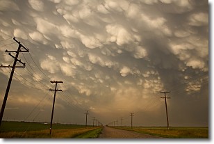
Weather Topic: What are Mammatus Clouds?
Home - Education - Cloud Types - Mammatus Clouds
 Next Topic: Nimbostratus Clouds
A mammatus cloud is a cloud with a unique feature which resembles
a web of pouches hanging along the base of the cloud.
In the United States, mammatus clouds tend to form in the warmer months, commonly
in the Midwest and eastern regions.
While they usually form at the bottom of a cumulonimbis cloud, they can also form
under altostratus, altocumulus, stratocumulus, and cirrus clouds. Mammatus clouds
warn that severe weather is close.
Next Topic: Nimbostratus Clouds
Current conditions powered by WeatherAPI.com


