Weather Alert in Hawaii
High Surf Advisory issued February 4 at 3:25PM HST until February 5 at 6:00AM HST by NWS Honolulu HI
AREAS AFFECTED: Big Island East; Big Island North
DESCRIPTION: ...HIGH SURF WARNING REMAINS IN EFFECT FOR NORTH AND WEST FACING SHORES OF NIIHAU KAUAI OAHU MOLOKAI...NORTH FACING SHORES OF MAUI AND WEST FACING SHORES OF THE BIG ISLAND... ...HIGH SURF ADVISORY REMAINS IN EFFECT FOR NORTH FACING SHORES OF THE BIG ISLAND... .Although the extra large northwest swell is now declining, surf along exposed north and west facing shores of Niihau, Kauai, Oahu, Molokai, north facing shores of Maui, and west facing shores of the Big Island will remain at warning levels this evening and tonight. Surf along these shores is expected to lower to advisory levels Thursday. Additionally, advisory level surf will remain possible along north facing shores of the Big Island through tonight. * WHAT...Surf of 10 to 15 feet. * WHERE...North facing shores of the Big Island. * WHEN...Until 6 AM HST Thursday. * IMPACTS...Moderate. Strong breaking waves and strong currents will make swimming dangerous.
INSTRUCTION: Heed all advice from ocean safety officials. When in doubt, don't go out.
Want more detail? Get the Complete 7 Day and Night Detailed Forecast!
Current U.S. National Radar--Current
The Current National Weather Radar is shown below with a UTC Time (subtract 5 hours from UTC to get Eastern Time).

National Weather Forecast--Current
The Current National Weather Forecast and National Weather Map are shown below.

National Weather Forecast for Tomorrow
Tomorrow National Weather Forecast and Tomorrow National Weather Map are show below.

North America Water Vapor (Moisture)
This map shows recent moisture content over North America. Bright and colored areas show high moisture (ie, clouds); brown indicates very little moisture present; black indicates no moisture.

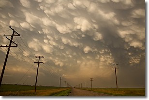
Weather Topic: What are Mammatus Clouds?
Home - Education - Cloud Types - Mammatus Clouds
 Next Topic: Nimbostratus Clouds
A mammatus cloud is a cloud with a unique feature which resembles
a web of pouches hanging along the base of the cloud.
In the United States, mammatus clouds tend to form in the warmer months, commonly
in the Midwest and eastern regions.
While they usually form at the bottom of a cumulonimbis cloud, they can also form
under altostratus, altocumulus, stratocumulus, and cirrus clouds. Mammatus clouds
warn that severe weather is close.
Next Topic: Nimbostratus Clouds
Weather Topic: What is Precipitation?
Home - Education - Precipitation - Precipitation
 Next Topic: Rain
Precipitation can refer to many different forms of water that
may fall from clouds. Precipitation occurs after a cloud has become saturated to
the point where its water particles are more dense than the air below the cloud.
In most cases, precipitation will reach the ground, but it is not uncommon for
precipitation to evaporate before it reaches the earth's surface.
When precipitation evaporates before it contacts the ground it is called Virga.
Graupel, hail, sleet, rain, drizzle, and snow are forms of precipitation, but fog
and mist are not considered precipitation because the water vapor which
constitutes them isn't dense enough to fall to the ground.
Next Topic: Rain
Current conditions powered by WeatherAPI.com


