Weather Alert in California
Red Flag Warning issued July 26 at 12:05PM PDT until July 27 at 11:00PM PDT by NWS Medford OR
AREAS AFFECTED: Western Klamath National Forest; Central Siskiyou County Including Shasta Valley; Siskiyou County from the Cascade Mountains East and South to Mt Shasta; Klamath Basin and the Fremont-Winema National Forest; South Central Oregon Desert including the BLM Land in Eastern Lake and Western Harney Counties
DESCRIPTION: * IMPACTS...Abundant lightning on dry fuels resulting in the potential for numerous new fire starts. * AFFECTED AREA...In California...the eastern portion of Fire weather zone 280, including the Scott Valley and areas eastward, all of Fire Weather zone 281 and the northern portion of Fire weather zone 284 from the Medicine Lake area northward. In Oregon...all of Fire weather zones 624 and 625. * THUNDERSTORMS...Scattered thunderstorms with abundant lightning. Storms are likely to be wet, but lightning strikes outside of precipitation cores are possible, and cause for concern for new fire starts. * OUTFLOW WINDS...Gusts of 35 to 50 mph could travel outward up to 25 miles from thunderstorm cores. * DETAILED URL...View the hazard area in detail at https://www.wrh.noaa.gov/map/?wfo=mfr
INSTRUCTION: Follow all fire restrictions. You can find your county's emergency sign up form as well as links to fire restrictions at weather.gov/medford/wildfire. One less spark, one less wildfire. Be sure you're signed up for your county's emergency alert system. Familiarize yourself with your emergency plan and make sure you listen to emergency services. Visit ready.gov/plan for more information. A Red Flag Warning is issued when we identify weather conditions that promote rapid spread of fire which may become life- threatening. This does not mean there is a fire. These conditions are either occurring now or will begin soon. It is important to have multiple ways to receive information from authorities.
Want more detail? Get the Complete 7 Day and Night Detailed Forecast!
Current U.S. National Radar--Current
The Current National Weather Radar is shown below with a UTC Time (subtract 5 hours from UTC to get Eastern Time).

National Weather Forecast--Current
The Current National Weather Forecast and National Weather Map are shown below.

National Weather Forecast for Tomorrow
Tomorrow National Weather Forecast and Tomorrow National Weather Map are show below.

North America Water Vapor (Moisture)
This map shows recent moisture content over North America. Bright and colored areas show high moisture (ie, clouds); brown indicates very little moisture present; black indicates no moisture.

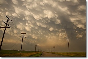
Weather Topic: What are Mammatus Clouds?
Home - Education - Cloud Types - Mammatus Clouds
 Next Topic: Nimbostratus Clouds
A mammatus cloud is a cloud with a unique feature which resembles
a web of pouches hanging along the base of the cloud.
In the United States, mammatus clouds tend to form in the warmer months, commonly
in the Midwest and eastern regions.
While they usually form at the bottom of a cumulonimbis cloud, they can also form
under altostratus, altocumulus, stratocumulus, and cirrus clouds. Mammatus clouds
warn that severe weather is close.
Next Topic: Nimbostratus Clouds
Weather Topic: What is Precipitation?
Home - Education - Precipitation - Precipitation
 Next Topic: Rain
Precipitation can refer to many different forms of water that
may fall from clouds. Precipitation occurs after a cloud has become saturated to
the point where its water particles are more dense than the air below the cloud.
In most cases, precipitation will reach the ground, but it is not uncommon for
precipitation to evaporate before it reaches the earth's surface.
When precipitation evaporates before it contacts the ground it is called Virga.
Graupel, hail, sleet, rain, drizzle, and snow are forms of precipitation, but fog
and mist are not considered precipitation because the water vapor which
constitutes them isn't dense enough to fall to the ground.
Next Topic: Rain
Current conditions powered by WeatherAPI.com


