Weather Alert in California
Red Flag Warning issued July 26 at 12:05PM PDT until July 27 at 11:00PM PDT by NWS Medford OR
AREAS AFFECTED: Western Klamath National Forest; Central Siskiyou County Including Shasta Valley; Siskiyou County from the Cascade Mountains East and South to Mt Shasta; Klamath Basin and the Fremont-Winema National Forest; South Central Oregon Desert including the BLM Land in Eastern Lake and Western Harney Counties
DESCRIPTION: * IMPACTS...Abundant lightning on dry fuels resulting in the potential for numerous new fire starts. * AFFECTED AREA...In California...the eastern portion of Fire weather zone 280, including the Scott Valley and areas eastward, all of Fire Weather zone 281 and the northern portion of Fire weather zone 284 from the Medicine Lake area northward. In Oregon...all of Fire weather zones 624 and 625. * THUNDERSTORMS...Scattered thunderstorms with abundant lightning. Storms are likely to be wet, but lightning strikes outside of precipitation cores are possible, and cause for concern for new fire starts. * OUTFLOW WINDS...Gusts of 35 to 50 mph could travel outward up to 25 miles from thunderstorm cores. * DETAILED URL...View the hazard area in detail at https://www.wrh.noaa.gov/map/?wfo=mfr
INSTRUCTION: Follow all fire restrictions. You can find your county's emergency sign up form as well as links to fire restrictions at weather.gov/medford/wildfire. One less spark, one less wildfire. Be sure you're signed up for your county's emergency alert system. Familiarize yourself with your emergency plan and make sure you listen to emergency services. Visit ready.gov/plan for more information. A Red Flag Warning is issued when we identify weather conditions that promote rapid spread of fire which may become life- threatening. This does not mean there is a fire. These conditions are either occurring now or will begin soon. It is important to have multiple ways to receive information from authorities.
Want more detail? Get the Complete 7 Day and Night Detailed Forecast!
Current U.S. National Radar--Current
The Current National Weather Radar is shown below with a UTC Time (subtract 5 hours from UTC to get Eastern Time).

National Weather Forecast--Current
The Current National Weather Forecast and National Weather Map are shown below.

National Weather Forecast for Tomorrow
Tomorrow National Weather Forecast and Tomorrow National Weather Map are show below.

North America Water Vapor (Moisture)
This map shows recent moisture content over North America. Bright and colored areas show high moisture (ie, clouds); brown indicates very little moisture present; black indicates no moisture.

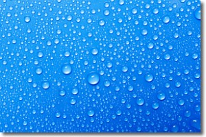
Weather Topic: What is Condensation?
Home - Education - Precipitation - Condensation
 Next Topic: Contrails
Condensation is the process which creates clouds, and therefore
it is a crucial process in the water cycle.
Condensation is the change of matter from a state of gas into a state of liquid,
and it happens because water molecules release heat into the atmosphere and
become organized into a more closely packed structure, what we might see as
water droplets.
Water is always present in the air around us as a vapor, but it's too small for
us to see. When water undergoes the process of condensation it becomes organized
into visible water droplets. You've probably seen condensation happen before on the
surface of a cold drink!
Next Topic: Contrails
Weather Topic: What are Cumulonimbus Clouds?
Home - Education - Cloud Types - Cumulonimbus Clouds
 Next Topic: Cumulus Clouds
The final form taken by a growing cumulus cloud is the
cumulonimbus cloud, which is very tall and dense.
The tower of a cumulonimbus cloud can soar 23 km into the atmosphere, although
most commonly they stop growing at an altitude of 6 km.
Even small cumulonimbus clouds appear very large in comparison to other cloud types.
They can signal the approach of stormy weather, such as thunderstorms or blizzards.
Next Topic: Cumulus Clouds
Current conditions powered by WeatherAPI.com


