Weather Alert in California
Red Flag Warning issued July 26 at 12:05PM PDT until July 27 at 11:00PM PDT by NWS Medford OR
AREAS AFFECTED: Western Klamath National Forest; Central Siskiyou County Including Shasta Valley; Siskiyou County from the Cascade Mountains East and South to Mt Shasta; Klamath Basin and the Fremont-Winema National Forest; South Central Oregon Desert including the BLM Land in Eastern Lake and Western Harney Counties
DESCRIPTION: * IMPACTS...Abundant lightning on dry fuels resulting in the potential for numerous new fire starts. * AFFECTED AREA...In California...the eastern portion of Fire weather zone 280, including the Scott Valley and areas eastward, all of Fire Weather zone 281 and the northern portion of Fire weather zone 284 from the Medicine Lake area northward. In Oregon...all of Fire weather zones 624 and 625. * THUNDERSTORMS...Scattered thunderstorms with abundant lightning. Storms are likely to be wet, but lightning strikes outside of precipitation cores are possible, and cause for concern for new fire starts. * OUTFLOW WINDS...Gusts of 35 to 50 mph could travel outward up to 25 miles from thunderstorm cores. * DETAILED URL...View the hazard area in detail at https://www.wrh.noaa.gov/map/?wfo=mfr
INSTRUCTION: Follow all fire restrictions. You can find your county's emergency sign up form as well as links to fire restrictions at weather.gov/medford/wildfire. One less spark, one less wildfire. Be sure you're signed up for your county's emergency alert system. Familiarize yourself with your emergency plan and make sure you listen to emergency services. Visit ready.gov/plan for more information. A Red Flag Warning is issued when we identify weather conditions that promote rapid spread of fire which may become life- threatening. This does not mean there is a fire. These conditions are either occurring now or will begin soon. It is important to have multiple ways to receive information from authorities.
Want more detail? Get the Complete 7 Day and Night Detailed Forecast!
Current U.S. National Radar--Current
The Current National Weather Radar is shown below with a UTC Time (subtract 5 hours from UTC to get Eastern Time).

National Weather Forecast--Current
The Current National Weather Forecast and National Weather Map are shown below.

National Weather Forecast for Tomorrow
Tomorrow National Weather Forecast and Tomorrow National Weather Map are show below.

North America Water Vapor (Moisture)
This map shows recent moisture content over North America. Bright and colored areas show high moisture (ie, clouds); brown indicates very little moisture present; black indicates no moisture.

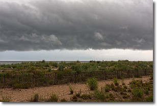
Weather Topic: What are Shelf Clouds?
Home - Education - Cloud Types - Shelf Clouds
 Next Topic: Sleet
A shelf cloud is similar to a wall cloud, but forms at the front
of a storm cloud, instead of at the rear, where wall clouds form.
A shelf cloud is caused by a series of events set into motion by the advancing
storm; first, cool air settles along the ground where precipitation has just fallen.
As the cool air is brought in, the warmer air is displaced, and rises above it,
because it is less dense. When the warmer air reaches the bottom of the storm cloud,
it begins to cool again, and the resulting condensation is a visible shelf cloud.
Next Topic: Sleet
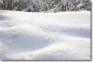
Weather Topic: What is Snow?
Home - Education - Precipitation - Snow
 Next Topic: Stratocumulus Clouds
Snow is precipitation taking the form of ice crystals. Each ice crystal, or snowflake,
has unique characteristics, but all of them grow in a hexagonal structure.
Snowfall can last for sustained periods of time and result in significant buildup
of snow on the ground.
On the earth's surface, snow starts out light and powdery, but as it begins to melt
it tends to become more granular, producing small bits of ice which have the consistency of
sand. After several cycles of melting and freezing, snow can become very dense
and ice-like, commonly known as snow pack.
Next Topic: Stratocumulus Clouds
Current conditions powered by WeatherAPI.com


