Weather Alert in Indiana
Flood Warning issued April 4 at 5:10AM EDT by NWS Northern Indiana
AREAS AFFECTED: Carroll, IN; Pulaski, IN; White, IN
DESCRIPTION: ...The Flood Warning continues for the following rivers in Indiana... Ohio... Wabash River near Linn Grove affecting Wells and Adams Counties. Eel River at North Manchester affecting Cass IN, Whitley, Kosciusko, Miami and Wabash Counties. Tippecanoe River near Ora affecting Pulaski County. Tippecanoe River above Winamac affecting Pulaski, Carroll and White Counties. Blanchard River at Ottawa affecting Putnam County. Maumee River at Napoleon affecting Henry County. Maumee River near Defiance affecting Defiance and Henry Counties. Maumee River at Fort Wayne affecting Paulding and Allen IN Counties. Saint Joseph River Ohio below Montpelier affecting Williams County. Saint Joseph River Ohio near St. Joe River Ft. Wayne affecting Allen IN County. Saint Joseph River Ohio near Newville affecting De Kalb, Allen IN and Defiance Counties. Saint Marys River near Decatur affecting Allen IN, Van Wert and Adams Counties. Tiffin River at Stryker affecting Defiance, Fulton OH and Williams Counties. North Branch Elkhart River at Cosperville affecting Noble County. ...The Flood Warning is extended for the following rivers in Indiana... Yellow River at Plymouth affecting St. Joseph, Marshall and Starke Counties. For the Tippecanoe River...including Ora, Winamac, Norway Dam... Moderate flooding is forecast. For the Wabash River...including Linn Grove, Bluffton IN, Wabash, Logansport...Minor flooding is forecast. For the Eel River...including North Manchester...Minor flooding is forecast. For the Yellow River...including Plymouth, Knox...Minor flooding is forecast. For the Blanchard River...including Ottawa...Minor flooding is forecast. For the Maumee River...including Fort Wayne, Defiance, Napoleon... Minor flooding is forecast. For the Saint Joseph River Ohio...including Montpelier, Newville, St. Joe River Ft. Wayne...Moderate flooding is forecast. For the Saint Marys River...including Decatur, St. Mary's River near Fort Wayne...Minor flooding is forecast. For the Tiffin River...including Stryker...Minor flooding is forecast. For the Elkhart River...including Goshen, Cosperville...Minor flooding is forecast. * WHAT...Moderate flooding is forecast. * WHERE...Tippecanoe River above Winamac. * WHEN...From this afternoon until further notice. * IMPACTS...At 11.0 feet, Extensive residential flooding is in progress. * ADDITIONAL DETAILS... - At 5:00 AM EDT Saturday the stage was 9.6 feet. - Forecast...The river is expected to rise above flood stage this afternoon and continue rising to a crest of 11.1 feet early Monday morning. - Flood stage is 10.0 feet. - http://www.weather.gov/safety/flood
INSTRUCTION: Turn around, don't drown when encountering flooded roads. Most flood deaths occur in vehicles. Detailed river forecasts and additional information can be found at www.weather.gov/iwx under Rivers and Lakes. The next statement will be issued this evening at 1115 PM EDT /1015 PM CDT/.
Want more detail? Get the Complete 7 Day and Night Detailed Forecast!
Current U.S. National Radar--Current
The Current National Weather Radar is shown below with a UTC Time (subtract 5 hours from UTC to get Eastern Time).

National Weather Forecast--Current
The Current National Weather Forecast and National Weather Map are shown below.

National Weather Forecast for Tomorrow
Tomorrow National Weather Forecast and Tomorrow National Weather Map are show below.

North America Water Vapor (Moisture)
This map shows recent moisture content over North America. Bright and colored areas show high moisture (ie, clouds); brown indicates very little moisture present; black indicates no moisture.

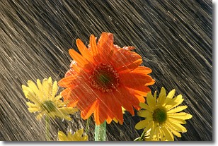
Weather Topic: What is Rain?
Home - Education - Precipitation - Rain
 Next Topic: Shelf Clouds
Precipitation in the form of water droplets is called rain.
Rain generally has a tendency to fall with less intensity over a greater period
of time, and when rainfall is more severe it is usually less sustained.
Rain is the most common form of precipitation and happens with greater frequency
depending on the season and regional influences. Cities have been shown to have
an observable effect on rainfall, due to an effect called the urban heat island.
Compared to upwind, monthly rainfall between twenty and forty miles downwind of
cities is 30% greater.
Next Topic: Shelf Clouds
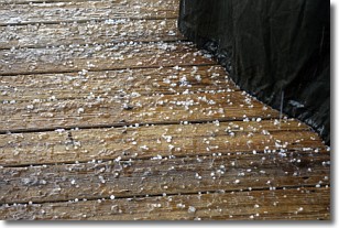
Weather Topic: What is Sleet?
Home - Education - Precipitation - Sleet
 Next Topic: Snow
Sleet is a form of precipitation in which small ice pellets are the primary
components. These ice pellets are smaller and more translucent than hailstones,
and harder than graupel. Sleet is caused by specific atmospheric conditions and
therefore typically doesn't last for extended periods of time.
The condition which leads to sleet formation requires a warmer body of air to be
wedged in between two sub-freezing bodies of air. When snow falls through a warmer
layer of air it melts, and as it falls through the next sub-freezing body of air
it freezes again, forming ice pellets known as sleet. In some cases, water
droplets don't have time to freeze before reaching the surface and the result is
freezing rain.
Next Topic: Snow
Current conditions powered by WeatherAPI.com


