Weather Alert in Arkansas
Flood Advisory issued June 10 at 2:39PM CDT by NWS Tulsa OK
AREAS AFFECTED: Franklin, AR; Johnson, AR; Logan, AR
DESCRIPTION: ...The Flood Advisory continues for the following rivers in Oklahoma...Arkansas... Red River at Arthur City affecting Choctaw County. Arkansas River at Ozark Lock and Dam affecting Logan, Johnson and Franklin Counties. * WHAT...Flooding caused by excessive rainfall continues. * WHERE...Arkansas River at Ozark Lock and Dam. * WHEN...Until further notice. * IMPACTS...At 355.5 feet, the river remains in its banks, but access to Okane Island may be cut off. At 357.0 feet, flooding affects agricultural use lands along the river downstream of the lock and dam in Franklin County. Gas fields are also subject to flooding downstream. Equipment and livestock should be moved to higher ground. North 5th Street in Logan County near the Six Mile Levee begins to flood and may cut off access to a nearby residence. * ADDITIONAL DETAILS... - At 2:00 PM CDT Tuesday the stage was 354.7 feet. - Forecast...The river is expected to rise to a crest of 356.9 feet Thursday evening. The river will then fluctuate near flood stage through Friday before falling. - Action stage is 355.5 feet. - Flood stage is 357.0 feet. - http://www.weather.gov/safety/flood
INSTRUCTION: N/A
Want more detail? Get the Complete 7 Day and Night Detailed Forecast!
Current U.S. National Radar--Current
The Current National Weather Radar is shown below with a UTC Time (subtract 5 hours from UTC to get Eastern Time).

National Weather Forecast--Current
The Current National Weather Forecast and National Weather Map are shown below.

National Weather Forecast for Tomorrow
Tomorrow National Weather Forecast and Tomorrow National Weather Map are show below.

North America Water Vapor (Moisture)
This map shows recent moisture content over North America. Bright and colored areas show high moisture (ie, clouds); brown indicates very little moisture present; black indicates no moisture.

Weather Topic: What is Sleet?
Home - Education - Precipitation - Sleet
 Next Topic: Snow
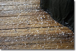
Sleet is a form of precipitation in which small ice pellets are the primary
components. These ice pellets are smaller and more translucent than hailstones,
and harder than graupel. Sleet is caused by specific atmospheric conditions and
therefore typically doesn't last for extended periods of time.
The condition which leads to sleet formation requires a warmer body of air to be
wedged in between two sub-freezing bodies of air. When snow falls through a warmer
layer of air it melts, and as it falls through the next sub-freezing body of air
it freezes again, forming ice pellets known as sleet. In some cases, water
droplets don't have time to freeze before reaching the surface and the result is
freezing rain.
Next Topic: Snow
Weather Topic: What are Stratocumulus Clouds?
Home - Education - Cloud Types - Stratocumulus Clouds
 Next Topic: Stratus Clouds
Stratocumulus clouds are similar to altocumulus clouds in their
fluffy appearance, but have a slightly darker shade due to their additional mass.
A good way to distinguish the two cloud types is to hold your hand out and measure
the size of an individual cloud; if it is the size of your thumb it is generally
an altocumulus cloud, if it is the size of your hand it is generally a
stratocumulus cloud.
It is uncommon for stratocumulus clouds to produce precipitation, but if they do
it is usually a light rain or snow.
Next Topic: Stratus Clouds
Current conditions powered by WeatherAPI.com


