Weather Alert in Iowa
Winter Storm Warning issued February 20 at 5:17AM CST until February 20 at 9:00AM CST by NWS La Crosse WI
AREAS AFFECTED: Howard; Winneshiek; Allamakee; Floyd; Chickasaw; Fayette; Clayton; Houston; La Crosse; Vernon; Crawford; Richland; Grant
DESCRIPTION: ...MODERATE TO HEAVY SNOW EARLY THIS MORNING... .A winter storm is impacting the region early this morning and gradually winds down later this morning. The band of heaviest snow amounts is expected to be 30 to 40 miles wide at most. There will be a very sharp cutoff in amounts on the northwest side of the snow band with impacts varying greatly in the span of just a few miles. Travel will be hazardous in the areas that see the heaviest snow!. * WHAT...Heavy snow with accumulations between 6 and 10 inches, locally higher in spots. Winds gusting as high as 40 mph. * WHERE...Portions of north central and northeast Iowa, southeast Minnesota, and southwest and west central Wisconsin. * WHEN...Until 9 AM CST this morning. * IMPACTS...Plan on slippery road conditions. The hazardous conditions could impact the Friday morning commute. Gusty winds could bring down tree branches.
INSTRUCTION: If you must travel, keep an extra flashlight, food, and water in your vehicle in case of an emergency. In Iowa, visit 511ia.org for road conditions. In Minnesota, visit 511mn.org for road conditions. In Wisconsin, visit 511wi.gov for road conditions.
Want more detail? Get the Complete 7 Day and Night Detailed Forecast!
Current U.S. National Radar--Current
The Current National Weather Radar is shown below with a UTC Time (subtract 5 hours from UTC to get Eastern Time).

National Weather Forecast--Current
The Current National Weather Forecast and National Weather Map are shown below.

National Weather Forecast for Tomorrow
Tomorrow National Weather Forecast and Tomorrow National Weather Map are show below.

North America Water Vapor (Moisture)
This map shows recent moisture content over North America. Bright and colored areas show high moisture (ie, clouds); brown indicates very little moisture present; black indicates no moisture.

Weather Topic: What is Hail?
Home - Education - Precipitation - Hail
 Next Topic: Hole Punch Clouds
Hail is a form of precipitation which is recognized by large solid balls or
clumps of ice. Hail is created by thunderstorm clouds with strong updrafts of wind.
As the hailstones remain in the updraft, ice is deposited onto them until their
weight becomes heavy enough for them to fall to the earth's surface.
Hail storms can cause significant damage to crops, aircrafts, and man-made structures,
despite the fact that the duration is usually less than ten minutes.
Next Topic: Hole Punch Clouds
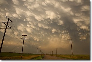
Weather Topic: What are Mammatus Clouds?
Home - Education - Cloud Types - Mammatus Clouds
 Next Topic: Nimbostratus Clouds
A mammatus cloud is a cloud with a unique feature which resembles
a web of pouches hanging along the base of the cloud.
In the United States, mammatus clouds tend to form in the warmer months, commonly
in the Midwest and eastern regions.
While they usually form at the bottom of a cumulonimbis cloud, they can also form
under altostratus, altocumulus, stratocumulus, and cirrus clouds. Mammatus clouds
warn that severe weather is close.
Next Topic: Nimbostratus Clouds
Current conditions powered by WeatherAPI.com


