Weather Alert in Kansas
Red Flag Warning issued February 18 at 1:05PM CST until February 19 at 8:00PM CST by NWS Springfield MO
AREAS AFFECTED: Bourbon; Crawford; Cherokee; Benton; Morgan; Miller; Maries; Vernon; St. Clair; Hickory; Camden; Pulaski; Phelps; Barton; Cedar; Polk; Dallas; Laclede; Texas; Jasper; Dade; Greene; Webster; Wright; Newton; Lawrence; Christian; Douglas; Howell; McDonald; Barry; Stone; Taney; Ozark
DESCRIPTION: The National Weather Service in Springfield has issued a Red Flag Warning, which is in effect from noon to 8 PM CST Thursday. * AFFECTED AREA...Fire Weather Zone 055 Benton, Fire Weather Zone 056 Morgan, Fire Weather Zone 057 Miller, Fire Weather Zone 058 Maries, Fire Weather Zone 066 Vernon, Fire Weather Zone 067 St. Clair, Fire Weather Zone 068 Hickory, Fire Weather Zone 069 Camden, Fire Weather Zone 070 Pulaski, Fire Weather Zone 071 Phelps, Fire Weather Zone 073 Bourbon, Fire Weather Zone 077 Barton, Fire Weather Zone 078 Cedar, Fire Weather Zone 079 Polk, Fire Weather Zone 080 Dallas, Fire Weather Zone 081 Laclede, Fire Weather Zone 082 Texas, Fire Weather Zone 088 Jasper, Fire Weather Zone 089 Dade, Fire Weather Zone 090 Greene, Fire Weather Zone 091 Webster, Fire Weather Zone 092 Wright, Fire Weather Zone 093 Newton, Fire Weather Zone 094 Lawrence, Fire Weather Zone 095 Christian, Fire Weather Zone 096 Douglas, Fire Weather Zone 097 Crawford, Fire Weather Zone 097 Howell, Fire Weather Zone 101 Cherokee, Fire Weather Zone 101 McDonald, Fire Weather Zone 102 Barry, Fire Weather Zone 103 Stone, Fire Weather Zone 104 Taney and Fire Weather Zone 105 Ozark. * TIMING...From noon to 8 PM CST Thursday. * WINDS...West 15 to 25 mph with gusts up to 35 mph. * RELATIVE HUMIDITY...As low as 17 percent. * TEMPERATURES...Up to 72. * IMPACTS...Any fire that develops will catch and spread quickly. Outdoor burning is not recommended.
INSTRUCTION: A Red Flag Warning means that critical fire weather conditions are either occurring now, or will shortly. A combination of strong winds, low relative humidity, and warm temperatures can contribute to extreme fire behavior.
Want more detail? Get the Complete 7 Day and Night Detailed Forecast!
Current U.S. National Radar--Current
The Current National Weather Radar is shown below with a UTC Time (subtract 5 hours from UTC to get Eastern Time).

National Weather Forecast--Current
The Current National Weather Forecast and National Weather Map are shown below.

National Weather Forecast for Tomorrow
Tomorrow National Weather Forecast and Tomorrow National Weather Map are show below.

North America Water Vapor (Moisture)
This map shows recent moisture content over North America. Bright and colored areas show high moisture (ie, clouds); brown indicates very little moisture present; black indicates no moisture.

Weather Topic: What is Precipitation?
Home - Education - Precipitation - Precipitation
 Next Topic: Rain
Precipitation can refer to many different forms of water that
may fall from clouds. Precipitation occurs after a cloud has become saturated to
the point where its water particles are more dense than the air below the cloud.
In most cases, precipitation will reach the ground, but it is not uncommon for
precipitation to evaporate before it reaches the earth's surface.
When precipitation evaporates before it contacts the ground it is called Virga.
Graupel, hail, sleet, rain, drizzle, and snow are forms of precipitation, but fog
and mist are not considered precipitation because the water vapor which
constitutes them isn't dense enough to fall to the ground.
Next Topic: Rain
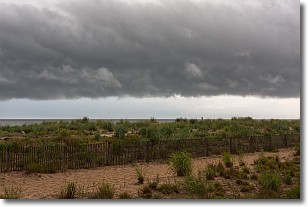
Weather Topic: What are Shelf Clouds?
Home - Education - Cloud Types - Shelf Clouds
 Next Topic: Sleet
A shelf cloud is similar to a wall cloud, but forms at the front
of a storm cloud, instead of at the rear, where wall clouds form.
A shelf cloud is caused by a series of events set into motion by the advancing
storm; first, cool air settles along the ground where precipitation has just fallen.
As the cool air is brought in, the warmer air is displaced, and rises above it,
because it is less dense. When the warmer air reaches the bottom of the storm cloud,
it begins to cool again, and the resulting condensation is a visible shelf cloud.
Next Topic: Sleet
Current conditions powered by WeatherAPI.com


