Weather Alerts for Montana
1. Avalanche Warning for: Kootenai/Cabinet Region
2. Avalanche Warning for: Kootenai/Cabinet Region; West Glacier Region
3. High Wind Warning for: Northern Sweet Grass; Melville Foothills
4. High Wind Warning for: Red Lodge Foothills
5. High Wind Watch for: Cascade County below 5000ft; Judith Basin County and Judith Gap; Upper Blackfoot and MacDonald Pass; Gates of the Mountains; Little Belt and Highwood Mountains; Big Belt, Bridger and Castle Mountains
6. High Wind Watch for: Central and Southeast Phillips; Northern Phillips; Southwest Phillips
7. High Wind Watch for: East Glacier Park Region; Northern High Plains; Southern Rocky Mountain Front; Southern High Plains
8. High Wind Watch for: Eastern Glacier, Western Toole, and Central Pondera
9. High Wind Watch for: Helena Valley; Meagher County Valleys; Elkhorn and Boulder Mountains; Canyon Ferry Area; Missouri Headwaters; Gallatin Valley
10. High Wind Watch for: Judith Gap; Southern Wheatland
11. High Wind Watch for: Livingston Area; Beartooth Foothills
12. High Wind Watch for: Madison River Valley; Beaverhead and Western Madison below 6000ft
13. High Wind Watch for: Northern Sweet Grass; Melville Foothills
14. High Wind Watch for: Western and Central Chouteau County; Bears Paw Mountains and Southern Blaine
15. Wind Advisory for: Livingston Area; Beartooth Foothills
16. Winter Storm Warning for: Absaroka/Beartooth Mountains
17. Winter Storm Warning for: Crazy Mountains
18. Winter Weather Advisory for: Bitterroot/Sapphire Mountains
19. Winter Weather Advisory for: Butte/Blackfoot Region
20. Winter Weather Advisory for: East Glacier Park Region
21. Winter Weather Advisory for: Little Belt and Highwood Mountains
22. Winter Weather Advisory for: Lower Clark Fork Region
23. Winter Weather Advisory for: Northwest Beaverhead County
24. Winter Weather Advisory for: Potomac/Seeley Lake Region
25. Winter Weather Advisory for: Pryor/Northern Bighorn Mountains; Northeast Bighorn Mountains
26. Winter Weather Advisory for: Southern Rocky Mountain Front; Upper Blackfoot and MacDonald Pass
27. Winter Weather Advisory for: West Glacier Region
Want more detail? Get the Complete 7 Day and Night Detailed Forecast!
Current U.S. National Radar--Current
The Current National Weather Radar is shown below with a UTC Time (subtract 5 hours from UTC to get Eastern Time).

National Weather Forecast--Current
The Current National Weather Forecast and National Weather Map are shown below.

National Weather Forecast for Tomorrow
Tomorrow National Weather Forecast and Tomorrow National Weather Map are show below.

North America Water Vapor (Moisture)
This map shows recent moisture content over North America. Bright and colored areas show high moisture (ie, clouds); brown indicates very little moisture present; black indicates no moisture.

Weather Topic: What are Altostratus Clouds?
Home - Education - Cloud Types - Altostratus Clouds
 Next Topic: Cirrocumulus Clouds
Altostratus clouds form at mid to high-level altitudes
(between 2 and 7 km) and are created by a warm, stable air mass which causes
water vapor
to condense as it rise through the atmosphere. Usually altostratus clouds are
featureless sheets characterized by a uniform color.
In some cases, wind punching through the cloud formation may give it a waved
appearance, called altostratus undulatus. Altostratus clouds
are commonly seen with other cloud formations accompanying them.
Next Topic: Cirrocumulus Clouds
Weather Topic: What are Cirrostratus Clouds?
Home - Education - Cloud Types - Cirrostratus Clouds
 Next Topic: Cirrus Clouds
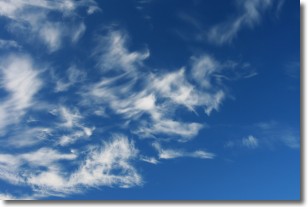
Cirrostratus clouds are high, thin clouds that form above
20,000 feet and are made mostly of ice crystals. They sometimes look like giant
feathers, horse tails, or curls of hair in the sky.
These clouds are pushed by the jet stream and can move at high speeds reaching
100 mph.
What do they indicate?
They indicate that a precipitation is likely within 24 hours.
Next Topic: Cirrus Clouds
Current conditions powered by WeatherAPI.com


